Published May 24, 2024
| Version v1
Dataset
Open
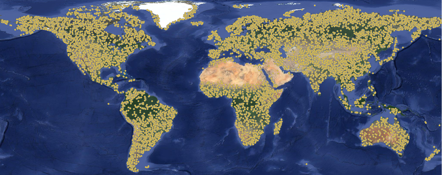
Global Pasture Watch - Grassland sampling design derived by Feature Space Coverage Sampling (FSCV) at 1-km spatial resolution
Authors/Creators

- 1. OpenGeoHub Foundation
-
2.
 World Resources Institute
Description
Sampling design used in the production of the global maps of grassland dynamics 2000–2022 at 30 m spatial resolution in the scope of the Global Pasture Wath initiative. The sampling desing was based in Feature Space Coverage Sampling and resulted in 10,000 sample tiles (1x1 km) distributed across the World, which were visual interpreted in Very-High Resolution imagery thorugh the QGIS plugin QGIS Fast Grid Inspection.
FSCS steps include:
- Short vegetation mask that includes all pixels mapped as mosaic, shrubland, grassland, and sparse vegetation in at least one year from 1993 to 2021 according to ESA/CCI global land cover (
gpw_short.veg.mask_esacci.lc_p_1km_s_19920101_20201231_go_epsg.3857_v1.tif), - 87 input raster layers (including vegetation indices, terrain, land temperature, climate and water variable),
- Principal Components Analysis (PCA) using all input layers,
- Selection of the 10 first components (explaining 75% of variance),
- K-Means with 10,000 clusters (targeted number of samples -
gpw_grassland_fscs.kmeans.cluster_c_1km_20000101_20221231_go_epsg.3857_v1.tif) - Calculation of euclidean distance (in the principal component space) of all 1-km pixels to the centre of each cluster,
- Selection of the pixel with the shortest distance for each cluster,
- Conversion of the selected pixels into sample tiles ()
The file gpw_grassland_fscs_tile.samples_1km_20000101_20221231_go_epsg.3857_v1.gpkg provides the sample tiles and include the follow collumns:
- X: Latitude in Web Mercator projection (EPSG:3857),
- Y: Longitude in Web Mercator projection (EPSG:3857),
- cluster_id: K-Means output ranging from 0—9999,
- cluster_distance: Distance from the selected sample to the centre of the cluster,
- cluster_size: Number o 1-km pixels inside the K-Means cluster,
- priority: Priority in the visual interpretation process.
Files
00-preview.png
Files
(319.8 MB)
| Name | Size | |
|---|---|---|
|
md5:5ec3e4cf52c260674b852b4b001f4756
|
1.1 MB | Preview Download |
|
md5:1dbffc269f7419cbcf12dd0e3d8b0a3e
|
257.9 MB | Preview Download |
|
md5:481921ae8207b77a4694162ed2e14fe8
|
2.4 MB | Download |
|
md5:8cf962963d614cf299b2612f0364bdd0
|
58.4 MB | Preview Download |
|
md5:d8f4ff17fbeeeb673fc6fa0509e0780b
|
1.1 kB | Preview Download |