Published November 26, 2024
| Version v1.2
Dataset
Open
Global Pasture Watch - Grassland sampling design derived by Feature Space Coverage Sampling (FSCS) at 1-km spatial resolution
Creators

- 1. OpenGeoHub Foundation
-
2.
 World Resources Institute
- 3. Remote Sensing and GIS Laboratory (LAPIG/UFG)
Description
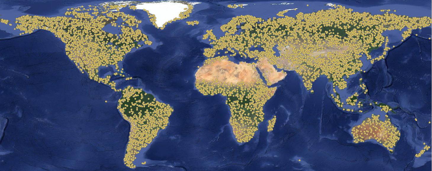
Sampling design used in the production of the global maps of grassland dynamics 2000–2022 at 30 m spatial resolution in the scope of the Global Pasture Wath initiative. The sampling desing was based in Feature Space Coverage Sampling and resulted in 10,000 sample tiles (1x1 km) distributed across the World, which were visual interpreted in Very-High Resolution imagery thorugh the QGIS plugin QGIS Fast Grid Inspection.
FSCS steps include:
- Short vegetation mask that includes all pixels mapped as mosaic, shrubland, grassland, and sparse vegetation in at least one year from 1993 to 2021 according to ESA/CCI global land cover (
gpw_short.veg.mask_esacci.lc_p_1km_s_19920101_20201231_go_epsg.3857_v1.tif), - 87 input raster layers (including vegetation indices, terrain, land temperature, climate and water variable),
- Principal Components Analysis (PCA) using all input layers,
- Selection of the 10 first components (explaining 75% of variance),
- K-Means with 10,000 clusters (targeted number of samples -
gpw_grassland_fscs.kmeans.cluster_c_1km_20000101_20221231_go_epsg.3857_v1.tif) - Calculation of euclidean distance (in the principal component space) of all 1-km pixels to the centre of each cluster,
- Selection of the pixel with the shortest distance for each cluster,
- Conversion of the selected pixels into sample tiles ()
The file gpw_grassland_fscs_tile.samples_1km_20000101_20221231_go_epsg.3857_v1.gpkg provides the sample tiles and include the follow collumns:
- X: Latitude in Web Mercator projection (EPSG:3857),
- Y: Longitude in Web Mercator projection (EPSG:3857),
- cluster_id: K-Means output ranging from 0—9999,
- cluster_distance: Distance from the selected sample to the centre of the cluster,
- cluster_size: Number o 1-km pixels inside the K-Means cluster, estimated using Web Mercator projection (EPSG:3857)
- cluster_size_equal_area: Number o 1-km pixels inside the K-Means cluster, estimated using Goode Homolosine Land projection (ESRI:54052)
- cluster_size_corr: Correction factor to adjust the area distortion due to Web Mercator projection, estimated by the difference in normalized propotional values of cluster_size and cluster_size_equal_area.
- rf_n_pred: Number of pixels predicted by a RF model trained to estimate probability to select the pixel closer to the centre of the KMeans cluster. The RF models were trained individually per each cluster using the 10 first components derived by PCA (
gpw_comps_fscs.pca_m_1km_20000101_20221231_go_epsg.3857_v1.tar.gz). - rf_samp_prob: Sampling probability based on RF model (rf_n_pred / cluster_size)
- rf_samp_wei: Sampling weight estimated in Web Mercator projection.
- rf_samp_wei_coor: Corrected sampling weight estimated in Goode Homolosine Land projection.
Related resources
- Maps of dominant grassland:
2000-2002 2003-2005 2006-2008 2009-2011 2012-2014 2015-2017 2018-2020 2021-2022 - Probability maps of cultivated grassland:
2000-2022 (All URLs) - Probability maps of natural/semi-natural grassland:
2000-2022 (All URLs) - Grassland reference samples based on VHR imagery (2000–2022):
GeoPackage files - Global machine learning models (Random Forest):
Parquet and joblib python files - Reference sampling design derived by FSCV:
GeoPackage and raster files - Harmonized reference samples based on existing LULC dataset:
GeoPackage and raster files - Source code for reproducibility:
GitHub release - Mapping feedback tool:
GeoWiki - Data catalogues:
OpenLandMap STAC Google Earth Engine
Support
For questions of bugs/inconsistencies related to the dataset raise a GitHub issue in https://github.com/wri/global-pasture-watch
Files
00-preview.png
Files
(26.5 GB)
| Name | Size | Download all |
|---|---|---|
|
md5:5ec3e4cf52c260674b852b4b001f4756
|
1.1 MB | Preview Download |
|
md5:992220e0fda3a2f241be19b06e9fdb64
|
4.4 GB | Download |
|
md5:e7c351a0e3c353490eb8ad7a79fa7098
|
21.8 GB | Download |
|
md5:1dbffc269f7419cbcf12dd0e3d8b0a3e
|
257.9 MB | Preview Download |
|
md5:17a1cb5a45122c354c11509ef8d9fc63
|
2.8 MB | Download |
|
md5:8cf962963d614cf299b2612f0364bdd0
|
58.4 MB | Preview Download |
|
md5:d8f4ff17fbeeeb673fc6fa0509e0780b
|
1.1 kB | Preview Download |