Crowd and community sourcing to update authoritative LULC data in urban areas
Authors/Creators
- 1. IGN-France (French National Mapping Agency)
- 2. International Institute for Applied Systems Analysis
Description
The French National Mapping Agency (Institut National de l'Information Géographique et Forestière - IGN) is responsible for producing and maintaining the spatial data sets for all of France. At the same time, they must satisfy the needs of different stakeholders who are responsible for decisions at multiple levels from local to national. IGN produces many different maps including detailed road networks and land cover/land use maps over time. The information contained in these maps is crucial for many of the decisions made about urban planning, resource management and landscape restoration as well as other environmental issues in France. Recently, IGN has started the process of creating a high-resolution land use land cover (LULC) maps, aimed at developing smart and accurate monitoring services of LULC over time. To help update and validate the French LULC database, citizens and interested stakeholders can contribute using the Paysages mobile and web applications. This approach presents an opportunity to evaluate the integration of citizens in the IGN process of updating and validating LULC data.
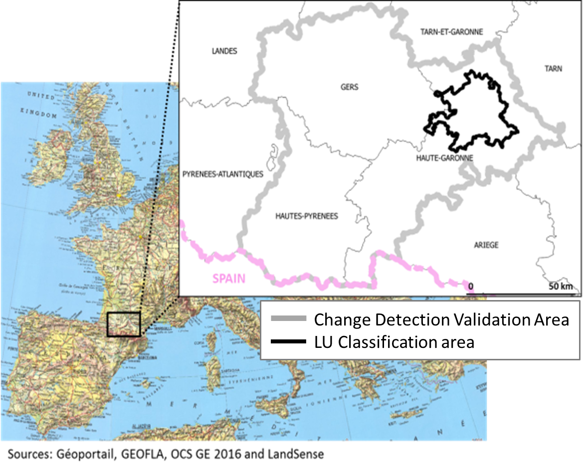
Dataset 1: Change detection validation 2019
This dataset contains web-based validations of changes detected by time series (2016 – 2019) analysis of Sentinel-2 satellite imagery. Validation was conducted using two high resolution orthophotos from respectively 2016 and 2019 as reference data. Two tools have been used: Paysages web application and LACO-Wiki. Both tools used the same validation design: blind validation and the same options. For each detected change, contributors are asked to validate if there is a change and if it is the case then to choose a LU or LC class from a pre-defined list of classes.
The dataset has the following characteristics:
- Time period of the change detection: 2016-2019.
- Time period of data collection: February 2019-December 2019
- Total number of contributors: 105
- Number of validated changes: 1048; each change was validated by between 1 to 6 contributors.
- Region of interest: Toulouse and surrounding areas
Associated files: 1- Change validation locations.png, 1-Change validation 2019 – Attributes.csv, 1-Change validation 2019.csv, 1-Change validation 2019.geoJSON
This dataset is licensed under a Creative Commons Attribution 4.0 International. It is attributed to the LandSense Citizen Observatory, IGN-France, and GeoVille.
Dataset 2: Land use classification 2019
The aim of this data collection campaign was to improve the LU classification of authoritative LULC data (OCS-GE 2016 ©IGN) for built-up area. Using the Paysages web platform, contributors are asked to choose a land use value among a list of pre-defined values for each location.
The dataset has the following characteristics:
- Time period of data collection: August 2019
- Types of contributors: Surveyors from the production department of IGN
- Total number of contributors: 5
- Total number of observations: 2711
- Data specifications of the OCS-GE ©IGN
- Region of interest: Toulouse and surrounding areas
Associated files: 2- LU classification points.png, 2-LU classification 2019 – Attributes.csv, 2-LU classification 2019.csv, 2-LU classification 2019.geoJSON
This dataset is licensed under a Creative Commons Attribution 4.0 International. It is attributed to the LandSense Citizen Observatory, IGN-France and the International Institute for Applied Systems Analysis.
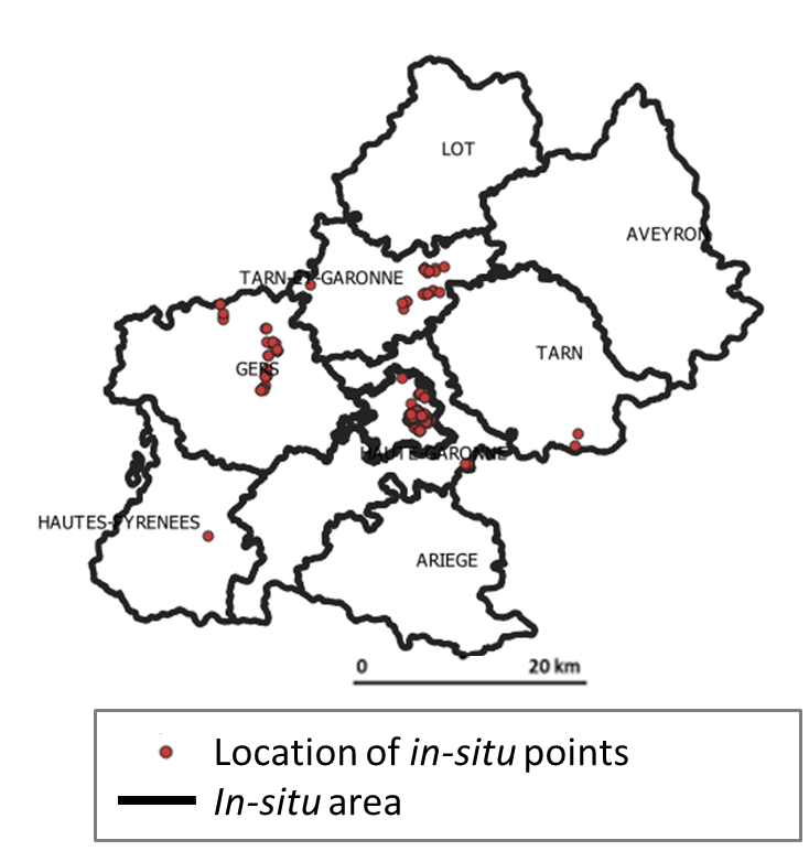
Dataset 3: In-situ validation 2018
The aim of this data collection campaign was to collect in-situ (ground-based) information, using the Paysages mobile application, to update authoritative LULC data. Contributors visit pre-determined locations, take photographs, of the point location and in the four cardinal directions away from the point and answer a few questions with respect with the task. Two tasks were defined:
- Classify the point by choosing a LU class between three classes: industrial (US2), commercial (US3) or residential (US5).
- Validate changes detected by the LandSense Change Detection Service: for each new detected change, the contributor was requested to validate the change and choose a LU and LC class from a pre-defined list of classes.
The dataset has the following characteristics
- Time period of data collection: June 2018 – October 2018
- Types of contributors: students from the School of Agricultural and Life Sciences and citizens
- Total number of contributors: 26
- Total number of observations: 281
- Total number of photos: 421
- Region of interest: Toulouse and surrounding areas
Associated files: 3- Insitu locations.png, 3- Insitu validation 2018 – Attributes.csv, 3- Insitu validation 2018.csv, 3- Insitu validation 2018.geoJSON
This dataset is licensed under a Creative Commons Attribution 4.0 International. It is attributed to the LandSense Citizen Observatory, IGN-France.
This project has received funding from the European Union’s Horizon 2020 research and innovation programme under grant agreement no 689812.
Files
001-Toulouse pilot study areas.png
Files
(5.0 MB)
| Name | Size | Download all |
|---|---|---|
|
md5:af770a1c10febe3fcd71385ca8f71ee2
|
1.1 MB | Preview Download |
|
md5:f6d63b3200e9d27a0cd10ff7e6a676d5
|
223.7 kB | Preview Download |
|
md5:64cc0366fb4a13650ba7ba6e2ca9cb50
|
1.5 kB | Preview Download |
|
md5:a9f3bd6d8385159b418da184703765ab
|
614.6 kB | Preview Download |
|
md5:305224b2771af9b246bd08384bdaa134
|
968.0 kB | Download |
|
md5:d0c52b6f314b9ad2a357df6070687d6a
|
735 Bytes | Preview Download |
|
md5:6f2b169a681d3cef9f371b080ca033d3
|
252.4 kB | Preview Download |
|
md5:80be36b8aee6cef0c4ee37792262aece
|
844.4 kB | Download |
|
md5:6f52ce5d83c73c9f0ececbfa522ee9ff
|
668.4 kB | Preview Download |
|
md5:e8b2f1cfb733de108d5890075f0af237
|
121.6 kB | Preview Download |
|
md5:11facc93506a24a23a5a6e96019408be
|
1.2 kB | Preview Download |
|
md5:0b836b209e36e8013ca18024ebbbfcf3
|
70.8 kB | Preview Download |
|
md5:997a187f39def8c23b6bd28108b4d871
|
185.6 kB | Download |
|
md5:b1686a6839eebc9c03051ebcf2e79ee0
|
6.2 kB | Preview Download |