Published August 15, 2025
| Version v3
Other
Open
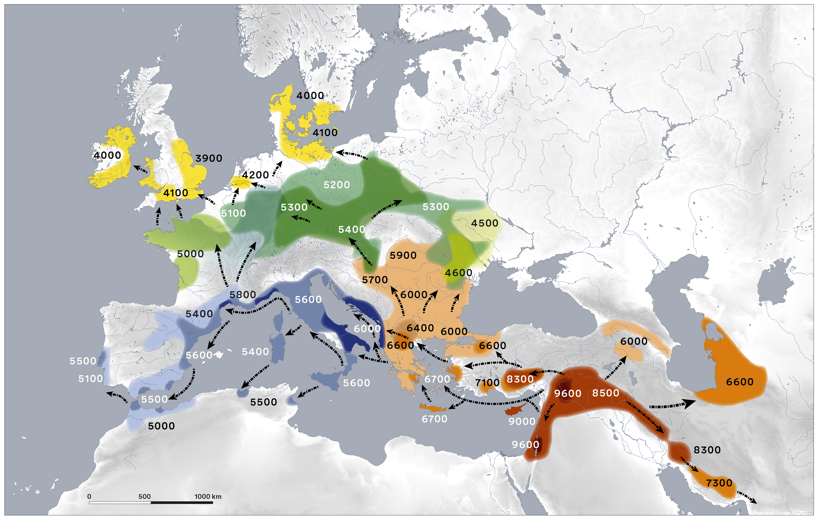
Map: Expansion of farming in western Eurasia, 9600 - 4000 cal BC (update vers. 2025.1)

-
1.
 LEIZA - Leibniz-Zentrum für Archäologie
- 2. Austrian Academy of Sciences, Austrian Archaeological Institute
Contributors
Others:
- 1. Österreichisches Archäologisches Institut
-
2.
LEIZA - Leibniz-Zentrum für Archäologie
Description
Condensed and simplified map of the spread of farming in western Eurasia. Pls cite as: Gronenborn/Horejs/Börner/Ober (LEIZA/ÖAI) 2025.1. Updates for many regions. Two colour and grey-scale resolutions available. PDF includes colour scheme and legend with approximate dates BCE (cal).
Files
LEIZA_OAI_2025-1_l.jpg
Files
(292.7 MB)
| Name | Size | Download all |
|---|---|---|
|
md5:640b9835cfdb0a53d66717e363c8933d
|
788.1 kB | Preview Download |
|
md5:d8ec62407d05869b49e2c4a82ca5df68
|
36.2 MB | Preview Download |
|
md5:d81ad61754975cbcc64cd8a583e50284
|
3.0 MB | Preview Download |
|
md5:634d223ead7cde1cb2245a64822529f5
|
2.9 MB | Preview Download |
|
md5:e0e18edaf98263e5f3955a133dac6bf3
|
108.2 MB | Preview Download |
|
md5:e24c0f239265a7763701ba50aa9dc87e
|
105.2 MB | Preview Download |
|
md5:254d223a0d3458d15c80c50ac0cf4b3d
|
36.4 MB | Preview Download |
Additional details
Dates
- Updated
-
2025-08-15
References
- Gronenborn/Horejs/Börner/Ober (LEIZA/ÖAI) 2025.1