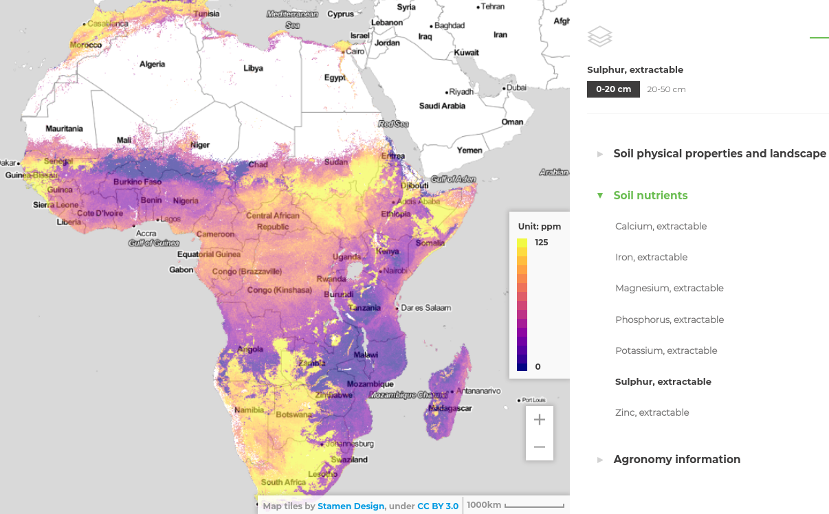
iSDAsoil: soil extractable Sulphur for Africa predicted at 30 m resolution at 0-20 and 20-50 cm depths
Authors/Creators

- 1. EnvirometriX
- 2. Innovative Solutions for Decision Agriculture Ltd (iSDA)
- 3. MultiOne
- 4. University of Belgrade
- 5. Rothamsted Research
- 6. World Agroforestry (ICRAF)
Description
iSDAsoil dataset soil extractable Sulphur (S) log-transformed predicted at 30 m resolution for 0–20 and 20–50 cm depth intervals. Data has been projected in WGS84 coordinate system and compiled as COG. Predictions have been generated using multi-scale Ensemble Machine Learning with 250 m (MODIS, PROBA-V, climatic variables and similar) and 30 m (DTM derivatives, Landsat, Sentinel-2 and similar) resolution covariates. For model training we use a pan-African compilations of soil samples and profiles (iSDA points, AfSPDB, and other national and regional soil datasets). Cite as:
Hengl, T., Miller, M.A.E., Križan, J. et al. African soil properties and nutrients mapped at 30 m spatial resolution using two-scale ensemble machine learning. Sci Rep 11, 6130 (2021). https://doi.org/10.1038/s41598-021-85639-y
To open the maps in QGIS and/or directly compute with them, please use the Cloud-Optimized GeoTIFF version.
Layer description:
- sol_log.s_mehlich3_m_30m_*..*cm_2001..2017_v0.13_wgs84.tif = predicted soil extractable Sulphur mean value,
- sol_log.s_mehlich3_md_30m_*..*cm_2001..2017_v0.13_wgs84.tif = predicted soil extractable Sulphur model (prediction) errors,
Model errors were derived using bootstrapping: md is derived as standard deviation of individual learners from 5-fold cross-validation (using spatial blocking). The model 5-fold cross-validation (mlr::makeStackedLearner) for this variable indicates:
Variable: log.s_mehlich3
R-square: 0.548
Fitted values sd: 0.423
RMSE: 0.384

Random forest model:
Call:
stats::lm(formula = f, data = d)

Residuals:
    Min      1Q  Median      3Q     Max
-2.5729 -0.2102 -0.0264  0.1694  5.0049

Coefficients:
               Estimate Std. Error t value Pr(>|t|)
(Intercept)    1.459208   4.154229   0.351    0.725
regr.ranger    0.937179   0.016167  57.967  < 2e-16 ***
regr.xgboost   0.002587   0.016252   0.159    0.874
regr.cubist    0.145396   0.010890  13.351  < 2e-16 ***
regr.nnet     -0.672062   1.796642  -0.374    0.708
regr.cvglmnet -0.045157   0.011256  -4.012 6.04e-05 ***
---
Signif. codes:  0 '***' 0.001 '**' 0.01 '*' 0.05 '.' 0.1 ' ' 1

Residual standard error: 0.3841 on 37530 degrees of freedom
Multiple R-squared:  0.5481,	Adjusted R-squared:  0.548
F-statistic:  9103 on 5 and 37530 DF,  p-value: < 2.2e-16
To back-transform values (y) to ppm use the following formula:
ppm = expm1( y / 10 )To submit an issue or request support please visit https://isda-africa.com/isdasoil
Notes
Files
001_africa_soil_extr_sulphur_30m.png
Files
(22.3 GB)
| Name | Size | |
|---|---|---|
|
md5:8606d020e10e4b8e6237f4c5c9db3f0e
|
591.1 kB | Preview Download |
|
md5:d686d9a9e3c0deeb30fb740cf06cebb6
|
5.4 kB | Preview Download |
|
md5:91c61b438069a26ee9c456b9edc01dea
|
6.7 GB | Preview Download |
|
md5:4913ee34872f19ab884ed0f6318d3ac4
|
7.1 GB | Preview Download |
|
md5:6ca2cc41528a255c6bc30c9cc823a6e8
|
4.4 GB | Preview Download |
|
md5:d9be56e115222c4bb2c7fb24c80f0450
|
4.1 GB | Preview Download |
Additional details
References
- Hengl, T., Leenaars, J. G., Shepherd, K. D., Walsh, M. G., Heuvelink, G. B., Mamo, T., ... & Wheeler, I. (2017). Soil nutrient maps of Sub-Saharan Africa: assessment of soil nutrient content at 250 m spatial resolution using machine learning. Nutrient Cycling in Agroecosystems, 109(1), 77-102.
- Hengl, T., MacMillan, R.A., (2019). Predictive Soil Mapping with R. OpenGeoHub foundation, Wageningen, the Netherlands, 370 pages, www.soilmapper.org, ISBN: 978-0-359-30635-0.
- Leenaars, J. G. B. (2014). Africa Soil Profiles Database, Version 1.2. A compilation of georeferenced and standardised legacy soil profile data for Sub-Saharan Africa (with dataset). Africa Soil Information Service (AfSIS) project (No. 2014/03). ISRIC-World Soil Information.
- Vågen, T. G., Winowiecki, L. A., Tondoh, J. E., Desta, L. T., & Gumbricht, T. (2016). Mapping of soil properties and land degradation risk in Africa using MODIS reflectance. Geoderma, 263, 216-225.