Above-Ground Biomass Prediction Dataset for Northeastern India: Satellite-Based Pixel-Level Estimates for Assam and Mizoram Forests
Creators
Description
Above-Ground Biomass Prediction Dataset for Northeastern India
Satellite-Based Pixel-Level Estimates for Assam and Mizoram Forests
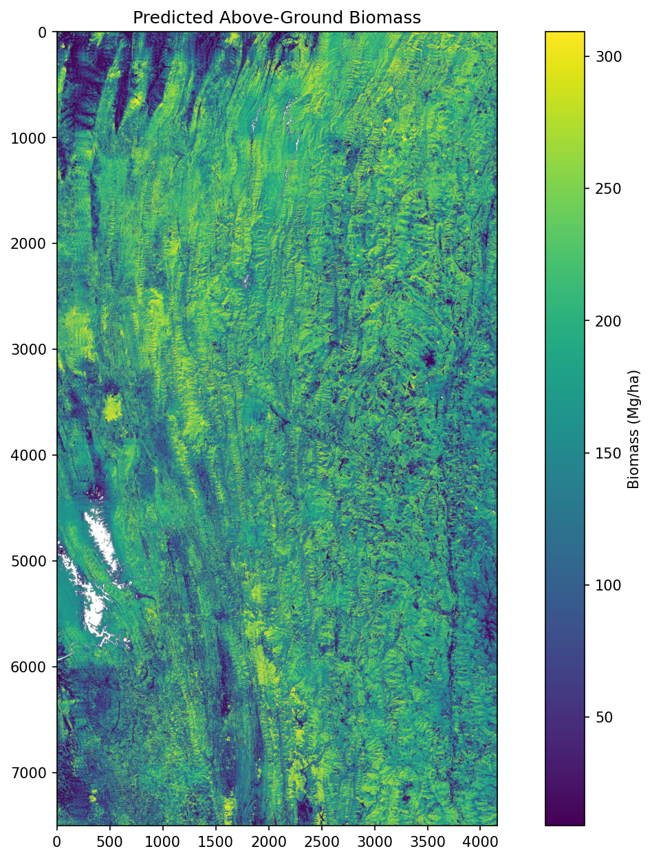
This dataset contains satellite-based above-ground biomass (AGB) predictions for two locations in northeastern Indian forests. It is specifically optimized for the forest regions in Assam and Mizoram. The predictions are generated using a deep learning model trained on ecologically similar forest sites across South and Southeast Asia. This work was developed by vertify.earth as part of the digital Monitoring, Reporting, and Verification (dMRV) for Himalayasproject, funded by Lacuna.
Dataset Structure
The dataset contains two locations. Each location includes four files.
File Descriptions
1. Input Images (input_image.tif)
-
Multi-sensor satellite data used for biomass prediction
-
Includes Sentinel-1 (SAR), Sentinel-2 (optical), and DEM data
-
Spatial resolution: 10 to 40 meters, depending on the sensor
-
Format: Multi-band GeoTIFF with geospatial referencing
2. Predicted Biomass Maps (predicted_biomass.tif)
-
Pixel-level biomass estimates in Mg/ha (megagrams per hectare)
-
Generated using StableResNet deep learning architecture
-
Model performance:
-
R² = 0.87
-
RMSE = 28.7 Mg/ha
-
MAE = 19.5 Mg/ha
-
-
Format: Single-band GeoTIFF
-
Typical value range: 40 to 460 Mg/ha
3. Visualization Maps (visualization.png)
-
Color-coded biomass maps for visual reference
-
PNG format, suitable for reports and presentations
-
Optimized color scales and legends for biomass density
4. Summary Statistics (statistics.txt)
-
Summary statistics of predicted biomass values
-
Includes mean, median, standard deviation, and min/max
-
Includes spatial distribution analysis
Model Information
Training Data
The model was trained on forests in:
-
India: Yellapur, Betul, Achanakmar
-
Thailand: Khaoyai
Sites were chosen for ecological similarity to northeastern India:
-
Monsoon-influenced climate
-
Comparable forest types (evergreen, semi-evergreen, moist deciduous)
-
Hilly terrain and similar biomass density range
Model Architecture
Custom StableResNet with:
-
Residual connections
-
Layer normalization
-
Designed for pixel-level regression stability
Feature Engineering
Features used include:
-
Spectral indices (NDVI, EVI, NDWI)
-
Texture features (LBP, GLCM)
-
Spatial gradients
-
PCA components
Regional Applicability
This dataset is tailored for:
-
Primary Use: Biomass mapping in Assam and Mizoram
-
Also Applicable To: Other northeastern Indian states
-
Forest Types: Tropical and subtropical, monsoon-affected
-
Terrain: Hilly and mountainous forest regions
Project Context
-
Organization: vertify.earth
-
Project: Digital Monitoring, Reporting, and Verification (dMRV) for Himalayas
-
Funding: Lacuna Fund
-
Purpose: Forest carbon monitoring and REDD+ support
Technical Specifications
| Item | Description |
|---|---|
| Number of Locations | 2 |
| Spatial Coverage | Assam and Mizoram, India |
| Temporal Coverage | 2024–2025 |
| Resolution | 10–40 meters |
| File Formats | GeoTIFF (raster), PNG (visualization), CSV/JSON (statistics) |
| Packaging | ZIP folder per location |
Usage Applications
-
Forest carbon stock assessments
-
REDD+ monitoring and reporting
-
Forest management planning
-
Climate change and biodiversity studies
-
Research on tropical forest dynamics
Data Quality and Validation
-
Validated against LiDAR-derived biomass data
-
Cross-validation across multiple forest sites
-
Performance Metrics:
-
R² = 0.87
-
RMSE = 28.7 Mg/ha
-
MAE = 19.5 Mg/ha
-
-
Includes quality flags for limited satellite coverage areas
Citation
If you use this dataset, please cite:
vertify.earth (2025). Above-Ground Biomass Prediction Dataset for Northeastern India: Satellite-Based Pixel-Level Estimates for Assam and Mizoram Forests. dMRV for Himalayas Project. Zenodo. https://doi.org/10.5281/zenodo.16536024
Files
biomass_prediction_mizoram.tif
Files
(7.2 GB)
| Name | Size | Download all |
|---|---|---|
|
md5:7e090c6b890e9515a1627e4db547709e
|
124.8 MB | Preview Download |
|
md5:41114101ac73115a99537e1ec933116f
|
22.6 MB | Preview Download |
|
md5:239be5b6a85a8881c90c69f320aef3e9
|
2.0 MB | Preview Download |
|
md5:1b5bdd9b7c83879e46e94945dbb0ac48
|
661.6 kB | Preview Download |
|
md5:35c3f70e6b2bc8e824a5ac2d5310fcf0
|
1.3 GB | Preview Download |
|
md5:b03e506fdbe847c6326cc2dfe3eea563
|
5.7 GB | Preview Download |
|
md5:4eab2de577a1d2cf3c4d4b78441ea98f
|
393 Bytes | Preview Download |
|
md5:13a4522b7276d3bdfbf18c8e79d60635
|
401 Bytes | Preview Download |
Additional details
Identifiers
- Other
- NA
Related works
- Is supplement to
- https://github.com/vertify-earth/biomass-prediction-NorthEastIndia (Other)
Dates
- Created
-
2025-07-28
Software
- Repository URL
- https://github.com/vertify-earth/biomass-prediction-NorthEastIndia
- Programming language
- Python
References
- NA