HarP: Harmonized Prior river-lake database
Authors/Creators

- 1. Department of Geography & Geographic Information, University of Illinois Urbana-Champaign, Urbana, IL, USA
- 2. Department of Geosciences, Virginia Tech, Blacksburg, VA, USA
- 3. Department of Geography, University of California, Los Angeles, CA, USA
- 4. Institute of Industrial Science, The University of Tokyo, Tokyo, Japan
- 5. Laboratoire d'Études en Géophysique et Océanographie Spatiales (LEGOS), Centre National d'Études Spatiales (CNES), Toulouse, France
- 6. Department of Earth, Marine and Environmental Sciences, University of North Carolina, Chapel Hill, NC, USA
Description
Contact: Md Safat Sikder (mssikder@illinois.edu), Jida Wang (jidaw@illinois.edu)
Citation
Sikder, M. S., Wang, J., Allen, G. H., Sheng, Y., Yamazaki, D., Crétaux, J.-F., and Pavelsky, T. M., 2024. HarP: Harmonized Prior river-lake database. Zenodo, https://doi.org/10.5281/zenodo.14205131.
If you only use the PLD-TopoCat dataset, please cite the following paper:
Sikder, M. S., Wang, J., Allen, G. H., Sheng, Y., Yamazaki, D., Song, C., Ding, M., Crétaux, J.-F., and Pavelsky, T. M., 2023. Lake-TopoCat: A global lake drainage topology and catchment dataset. Earth System Science Data, 15, 3483-3511, https://doi.org/10.5194/essd-15-3483-2023.
Data description and components
The Harmonized Prior river-lake database (HarP) for SWOT integrated the SWOT River Database (SWORD) (Altenau et al., 2021) and the SWOT Prior Lake Database (PLD) (Wang et al., 2023) into a geometrically (lake/river) explicit but topologically harmonized vector database to allow for coupled fluvial-lacustrine applications, including a synergistic use of both river and lake products from SWOT.
In addition to the input river network (SWORD v16) and lake database (PLD v106), we used the MERIT Hydro v1.0.1 (Yamazaki et al., 2019), a high-resolution (~90 m) global hydrography dataset, to develop this database.
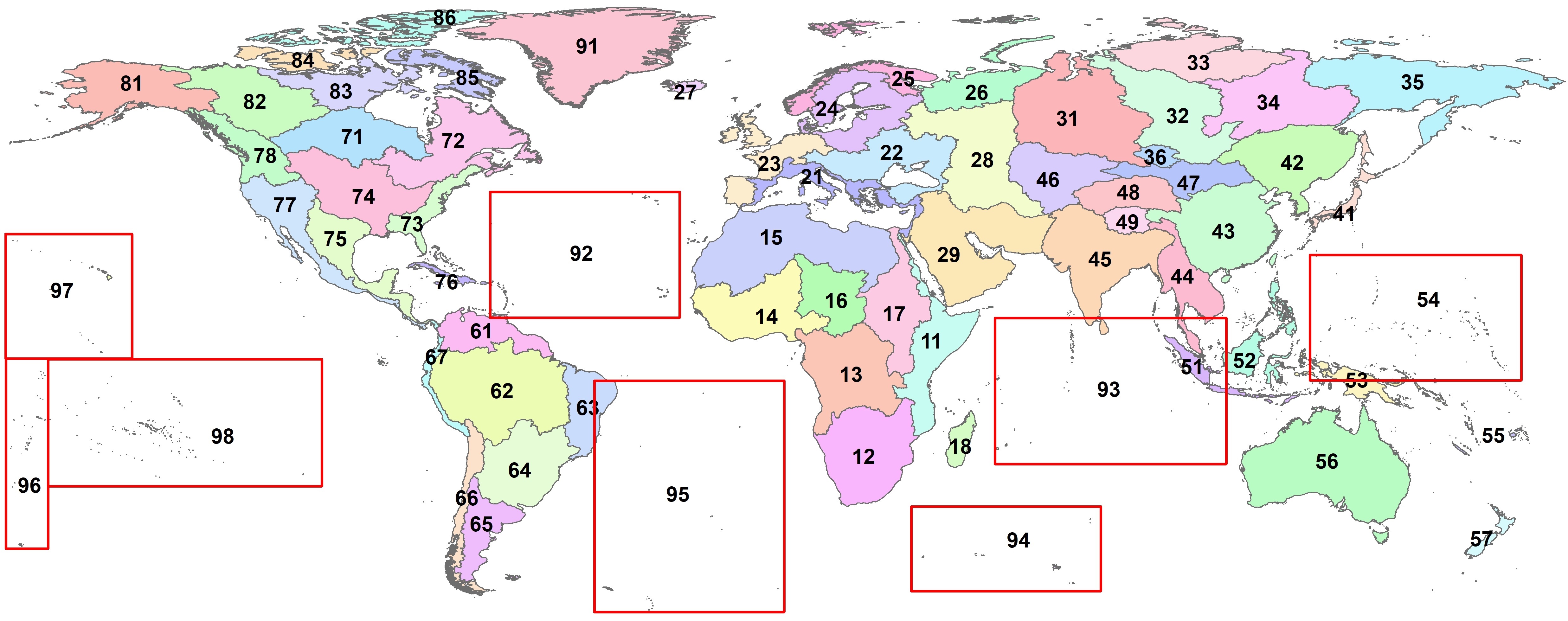
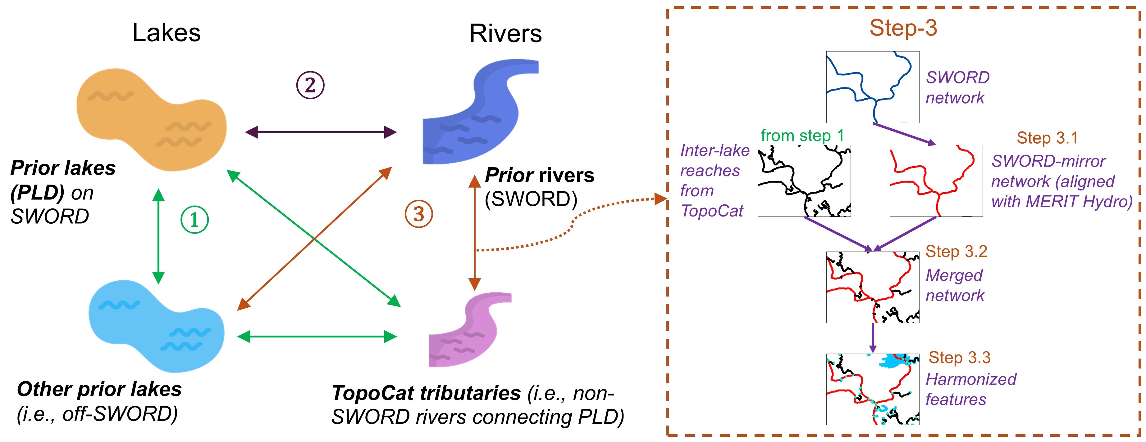
The SWORD-PLD harmonization process involves three major steps, with Step 3 being divided into three sub-steps. The processing chain is illustrated in the attached Figure "SWORD-PLD_harmonization_steps.jpg", as well as in Section 2 of the product description document. The HarP database consists of the outputs from each of the steps. For convenience, the global landmass (excluding Antarctica) was partitioned to 68 Pfafstetter Level-2 basins/regions, with their IDs shown in Figure "Pfaf2_basins.jpg" attached.
The HarP database consists of five datasets or components (outputs from each step), each with multiple features. The five datasets are described below, and more details are elaborated in the product description document.
1. Harmonized SWORD-PLD (file name "Harmonized_SWORD_PLD"): This is the fully harmonized SWORD-PLD dataset, the primary product of HarP (i.e., output of Step 3.3 in Figure "SWORD-PLD_harmonization_steps.jpg"). This dataset couples SWORD and PLD into a geometrically segmented but topologically integrated dataset at the node, reach, and catchment scales (stored by three feature layers, respectively):
(a) Harmonized feature nodes: Harmonized_feature_nodes_pfaf_xx
(b) Harmonized river network: Harmonized_river_network_pfaf_xx
(c) Harmonized feature catchments: Harmonized_feature_catchments_pfaf_xx
Note: ''pfaf_xx'' indicates the Pfafstetter Level-2 basin ID (shown in Fig. 'Pfaf2_basins.jpg').
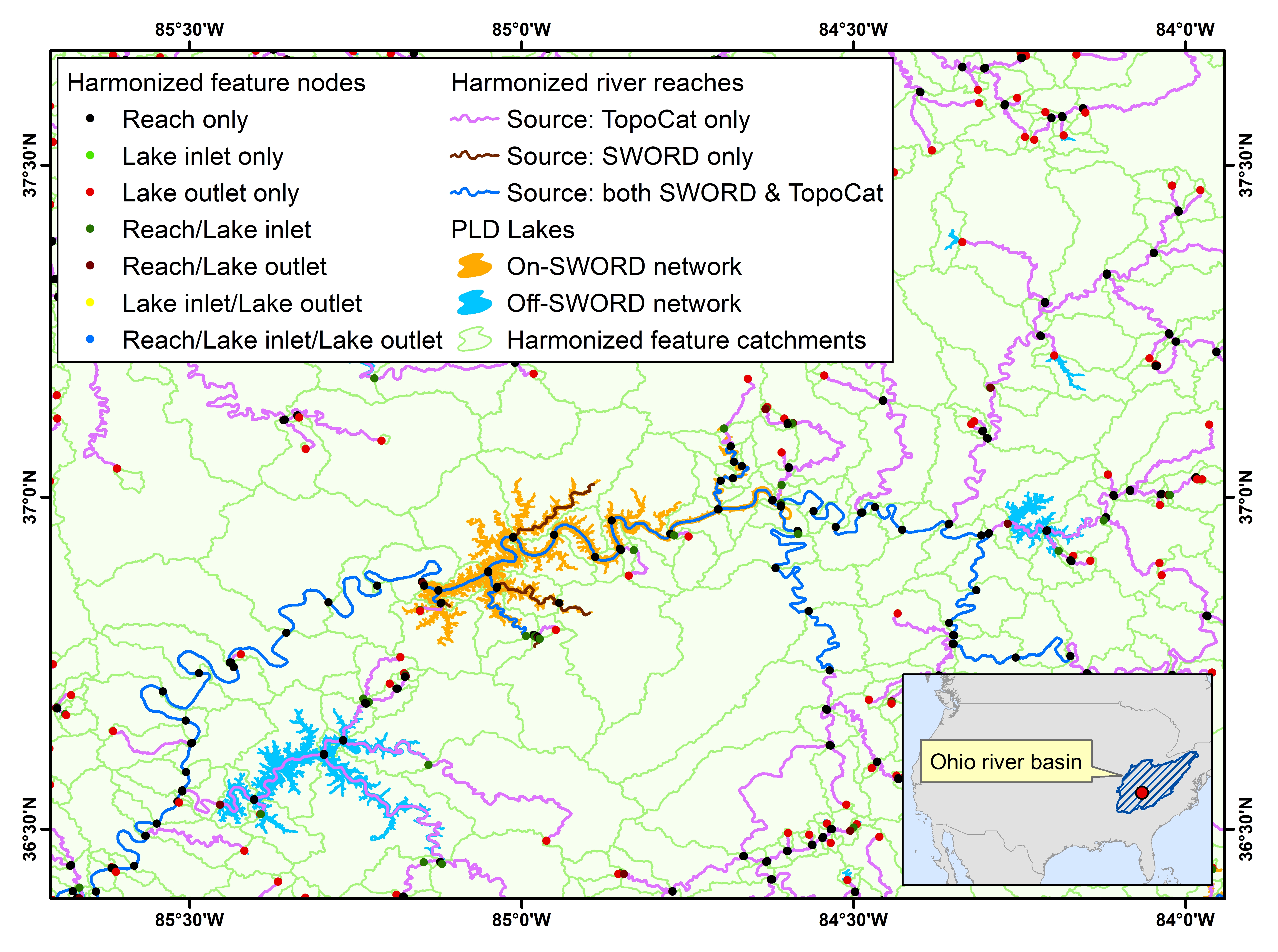
Figure "HarP_example.jpg", attached to this database, is an example of the fully harmonized SWORD-PLD dataset for the Ohio River Basin. The example shows three main features of the dataset: feature nodes (i.e., reach downstream ends, lake inlets, and lake outlets; see Fig. 3 in the product description document for definitions), river reaches (i.e., reaches characterized by SWORD alone, characterized by TopoCat alone, and shared by both SWORD and TopoCat), and catchments segmented by each of the feature nodes.
2. Intersected SWORD-PLD drainage configuration (file name "Intersected_SWORD_PLD"): This dataset is the intersected SWORD-PLD (prior river-lake) features (i.e., output of Step 2 in Figure "SWORD-PLD_harmonization_steps.jpg"). This dataset was constructed independently from Step 1 and Step 3. In this dataset, the original geometries of SWORD and PLD are not altered, but instead, their geometric and drainage topological relationships are configured in the attribute tables. This dataset consists of three features:
(a) Intersected reaches: Intersected_SWORD_reaches_pfaf_xx
(b) Intersected nodes: Intersected_SWORD_nodes_pfaf_xx
(c) Intersected lakes: Intersected_PLD_lakes_pfaf_xx
3. PLD-TopoCat (file name "PLD_TopoCat"): This dataset is the lake drainage topology and catchments (TopoCat) for PLD lakes (i.e., output of Step 1 in Figure "SWORD-PLD_harmonization_steps.jpg"). PLD-TopoCat was developed to generate detailed lake drainage topology and connecting paths, which were later used to configure the off-SWORD-network PLD lakes into the tributaries that drain to SWORD. PLD-TopoCat was generated from PLD v106 and MERIT Hydro. Details of the developiong process and algorithm for TopoCat can be found at Sikder at al., (2023). PLD-TopoCat dataset contains six features:
(a) Lake original polygon: PLD_lakes_pfaf_xx
(b) Lake raster polygon: Lake_raster_polygons_pfaf_xx
(c) Lake outlets: Lake_outlets_pfaf_xx
(d) Lake catchments: Lake_catchments_pfaf_xx
(e) Inter-lake reaches: Inter_lake_reaches_pfaf_xx
(f) Lake-network basins: Lake_network_basins_pfaf_xx
Note: full version of the PLD-TopoCat is available here.
4. SWORD-mirror network (file name "SWORD_mirror"): The SWORD-mirror network was constructed to facilitate the SWORD-TopoCat network merging process (i.e., output of Step 3.1 in Figure "SWORD-PLD_harmonization_steps.jpg"). It is essentially a replica of SWORD except that the original SWORD reaches are geometrically modified to be aligned with the topological/hydrographic information depicted in MERIT Hydro. The SWORD-mirror network consists of four features:
(a) SWORD-original reaches: SWORD_original_reaches_pfaf_xx
(b) SWORD-mirror prelim. reaches: SWORD_mirror_prelim_reaches_pfaf_xx
(c) SWORD-mirror reaches: SWORD_mirror_reaches_pfaf_xx
(d) SWORD-mirror reach catchments: SWORD_mirror_reach_catchments_pfaf_xx
5. Merged SWORD-mirror – TopoCat network (file name "SWORD_TopoCat_merged"): This dataset is the output of Step 3.2 in Figure "SWORD-PLD_harmonization_steps.jpg". It is essentially the merged product of the inter-lake reaches (from Step 2) and SWORD-mirror reaches (from Step 3.1). The merged SWORD-mirror – TopoCat network consists of three features:
(a) Merged SWORD-TopoCat reaches: SWORD_TopoCat_merged_reaches_pfaf_xx
(b) SWORD nodes at SWORD-TopoCat confluence: SWORD_TopoCat_confluence_nodes_pfaf_xx
(c) Reach catchments for merged network: SWORD_TopoCat_reach_catchments_pfaf_xx
The attribute tables for each of the feature components are explained in Section 4 of the product description document. All files of HarP are available in both shapefile and geodatabase formats.
Disclaimer
Authors of this dataset claim no responsibility or liability for any consequences related to the use, citation, or dissemination of HarP. For any quesitons, please contact Safat Sikder and Jida Wang.
Notes
Files
Harmonized_SWORD_PLD.gdb.zip
Files
(31.2 GB)
| Name | Size | Download all |
|---|---|---|
|
md5:471f247dfcfa95b5f3e0fdaec204e471
|
3.5 GB | Preview Download |
|
md5:c37bee4fe8d7f7b1dc5cd0d4014914c3
|
5.8 GB | Preview Download |
|
md5:6e61768c7e250c52ea457e24ffaac51d
|
7.0 MB | Preview Download |
|
md5:ea5e8df06c8b7af613982892ad5e40bb
|
186.2 MB | Preview Download |
|
md5:0d5423887215683173488a81e773c736
|
512.5 MB | Preview Download |
|
md5:5170b1c66fb456d5babecbf3eb65306b
|
1.3 MB | Preview Download |
|
md5:80f899ee83e2765ac5984c80556a8b58
|
4.6 GB | Preview Download |
|
md5:b359ee7eee7a0e4faa0fbc9eacbbc403
|
8.1 GB | Preview Download |
|
md5:67b291281aaca4442bb9b22424367dde
|
595.3 kB | Preview Download |
|
md5:3aadf34a3df6d376642b8957fd8a9057
|
505.8 MB | Preview Download |
|
md5:96dda3c13b73b5bb3348ad9bfa893ea4
|
1.6 GB | Preview Download |
|
md5:01f4366cbccd3e411945ea9c279384ad
|
2.2 GB | Preview Download |
|
md5:e5f1502f5156b2f7c1d5706372f75ffa
|
4.2 GB | Preview Download |
|
md5:3f93501672eeb31e9b4f4645a82f894e
|
1.8 MB | Preview Download |
Additional details
References
- Altenau, E. H., Pavelsky, T. M., Durand, M. T., Yang, X., Frasson, R. P. d. M., and Bendezu, L. (2021), The surface water and ocean topography (SWOT) mission river database (SWORD): A global river network for satellite data products, Water Resources Research, 57, e2021WR030054, https://doi.org/10.1029/2021WR030054.
- Sikder, M. S., Wang, J., Allen, G. H., Sheng, Y., Yamazaki, D., Song, C., Ding, M., Crétaux, J.-F., and Pavelsky, T. M. (2023), Lake-TopoCat: A global lake drainage topology and catchment dataset, Earth System Science Data, 15, 3483–3511, https://doi.org/10.5194/essd-15-3483-2023.
- Wang, J., Pottier, C., Cazals, C., Battude, M., Sheng, Y., Song, C., Sikder, M.S., Yang, X., Ke, L., Gosset, M., Oliveira, R., Grippa, M., Girard, F., Allen, G., Xu, X., Zhu, X., Biancamaria, S., Smith, L., Crétaux, J.-F., and Pavelsky, T. (2023), The Surface Water and Ocean Topography Mission (SWOT) Prior Lake Database (PLD): Lake mask and operational auxiliaries, Water Resources Research, https://doi.org/10.22541/au.170258987.72387777/v1 (revision submitted).
- Yamazaki, D., Ikeshima, D., Sosa, J., Bates, P. D., Allen, G. H., and Pavelsky, T. M. (2019), MERIT Hydro: a high-resolution global hydrography map based on latest topography dataset, Water Resources Research, 55, 5053–5073, https://doi.org/10.1029/2019WR024873.