Georeferenced and cropped "Half Inch" (1:126,720) maps of Burma (colonial period)
Creators
Description
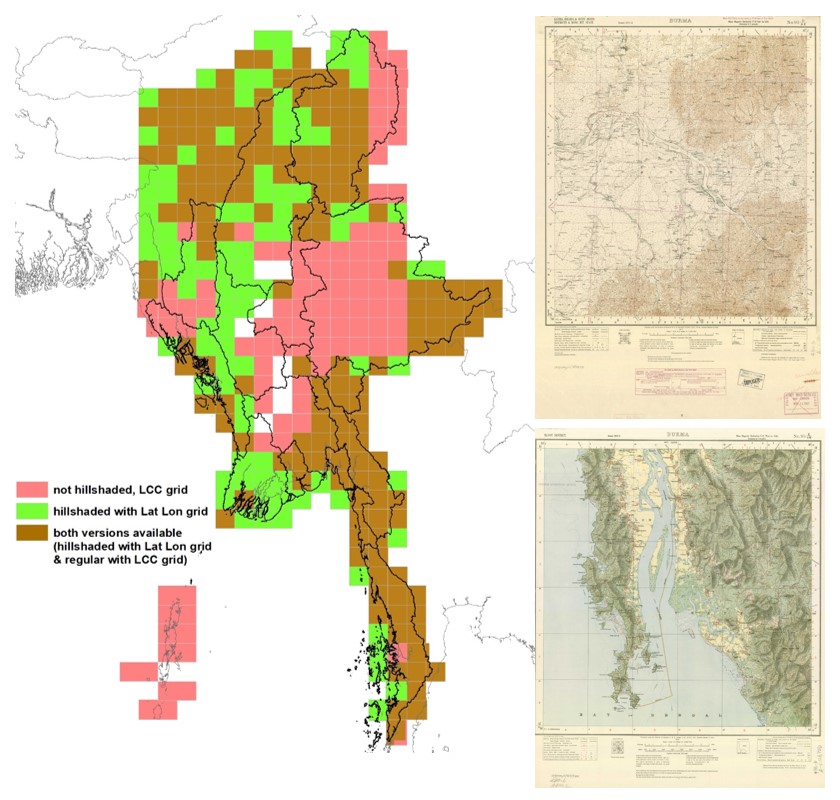
Georeferenced (to WGS1984) and cropped set of about 555 historic maps of Burma at a scale of 1 inch per two miles (1:126,720) covering most of the country. Those topographic maps, originally produced and published by the Great Trigonometrical Survey of India between 1878 and 1949, have been scanned and shared with the public as "Old Survey Of India Maps” Community under a CC BY 4.0 International Licence.
Each of the map sheet scans was georeferenced using the Latitude-Longitude corner coordinates in Everest 1830 projection. Those map sheets were cropped, keeping only the map area - to allow a seamless mosaic without the mapframe overlapping adjacent map sheets when several map sheets are put together in a GIS. Those cropped map sheets were projected from Everest 1830 to WGS1984 (EPSG:4326) - standard GPS - projection to make them easier to use and combine with other GIS data.
Many grid cells in this dataset are covered by 2 versions of map sheets - those with hill shade and only lat-lon grid and those without hill shade and featuring a LCC map grid.
Those map sheets can be loaded directly in any GIS such as QGIS or ESRI ArcGIS.
- The mm_HI_JBv2024_epsg4326 folder contains the cropped end georeferenced map sheets in jpg-format as well as accompagning georeference and metadata incl.
- The mm_HI_JBv2024_epsg4326_kmlLinks contains a KML file for each map sheet facilitating their easy use in Google Earth byt linking them the georeferenced map sheet file located in the mm_HI_JBv2024_epsg4326 folder.
- The mm_historicHI_EPSG4326.gdb contains three ESRI mosaic datasets to easily load all mapsheets, only mapheets with hillshading and lat-lon grid and only "regular" mapsheets without hillshading and LCC grid into ArcGIS
- The mm_HI_JBv2024_scanMaps folder contains the uncropped original map scans (renamed though) in jpg-format.
- The mm_historicTopoHI_JBv2024 is a masterlist cataloguing all map sheets for easier use and matching them with the original source files as shared via the "Old Survey Of India Maps” Community (e.g. to identify new mapsheets should new maps be released)
All georeferenced map scans are based on maps shared as part of the "Old Survey Of India Maps” via Zenodo. Links to each file can be found in the above mentined excel file and most can be also accessed through the zenodo repository below.
- https://zenodo.org/records/8040798 (128k Maps of South Asia, version 4, Published May 3, 2023)
The file naming convention is to first give the number of the 4 degree x 4 degree block followed by the letter (A to P) of the sixteen 1 degree x 1 degree blocks in each 4 degree block eg. 38 D, and this is followed by the cardinal direction letters (NE, NW, SE, SW) to indicate the 30x30 minutes sized map position in the 1 degree block.
This Number - Letter - Cardinal direction letter designation is followed by the year of the edition, followed by the map series type either HI-hs (hillshaded) or HI-reg (regular), followed by the map sheet title/name.
The original files as shared as part of the "Old Survey Of India Maps” have been renamed to further standardize the file naming, sometimes correcting them and to make them unique in the case several editions of the same map sheet were available.
Lineage: This version (1.01, Upload 2024-08-20) has some file attributes fixed.
Files
HI_georefMapsRepoContent.jpg
Files
(8.1 GB)
| Name | Size | Download all |
|---|---|---|
|
md5:3829bb411ba0a155c10f3703194d7204
|
151.6 kB | Preview Download |
|
md5:bdc11a57fdbd5acc0c9c2d9e0b3524c7
|
577.8 kB | Preview Download |
|
md5:e069e46ea9545ea5208b0c40ac9a2881
|
5.9 GB | Preview Download |
|
md5:d7d0cf6f407d9307640d38823288012c
|
2.2 GB | Preview Download |
|
md5:fed4ce249ed59d1887a56b043bb2d2b0
|
64.8 kB | Download |
Additional details
Related works
- Is derived from
- Dataset: 10.5281/zenodo.7894128 (DOI)