Georeferenced and cropped "63k Maps of Burma"
Creators
Description
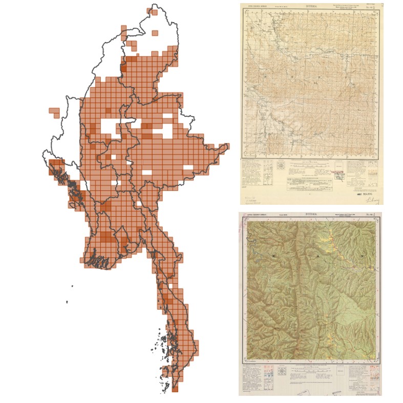
Georeferenced (to WGS1984) and cropped set of about 820 historic maps of Burma at a scale of 1 inch per mile (63,360) covering about 75% of the country. Those topographic maps, originally produced and published by the Great Trigonometrical Survey of India between 1899 and 1946, have been scanned and shared with the public as part of the "Old Survey Of India Maps” Community under a CC BY 4.0 International Licence. Many of these maps are reprints of earlier maps produced before the war. Most mapsheets are early editions (edition 1 or edition 2).
Each of the 820 map sheet scans was georeferenced using the Latitude-Longitude corner coordinates in Everest 1830 projection. Those map sheets were cropped, keeping only the map area - to allow a seamless mosaic without the mapframe overlapping adjacent map sheets when several map sheets are put together in a GIS. Those cropped map sheets were projected from Everest 1830 to WGS1984 (EPSG4326) - standard GPS - projection to make them easier to use and combine with other GIS data.
Those map sheets can be loaded directly in any GIS such as QGIS or ESRI ArcGIS as well as Google Earth.
- The mm_OI_JBv2024 folder contains the cropped end georeferenced map sheets in jpg-format as well as accompagning georeference and metadata incl.
- The mm_OI_JBv2024_kmlLinks contains kml files to easily load the mapsheets into Google Earth
- The mm_historicOI_EPSG4326.gdb contains an ESRI mosaic dataset to easily load all mapsheets into ArcGIS
- The mm_OI_JBv2024_scanMaps folder contains the uncropped original map scans (renamed though) in jpg-format.
- The mm_topoOI_JBv7_masterlist.xlsx is a masterlist cataloguing all map sheets for easier use and matching them with the original source files as shared as part of the "Old Survey Of India Maps" (e.g. to identify new mapsheets should new maps be released)
- The indexMaps folder contains small scale index maps to locate the map sheets using their map sheet Grid-Letter-nomenclature
All georeferenced map scans are based on maps shared by John Brown via Zenodo
- https://zenodo.org/records/8040798 (63k Maps of Burma, version 7, Published June 14, 2023)
- https://zenodo.org/records/10463372 (63k Maps of Burma--additional 1--20240105, version 1, Published January 5, 2024)
The file naming convention is to first give the number of the 4 degree x 4 degree block followed by the letter (A to P) of the sixteen 1 degree x 1 degree blocks in each 4 degree block eg. 38 D, and this is followed by a number from 1 to 16 to indicate the number of the map in the 1 degree block.
This Number Letter Number designation is followed by the map series type either OI (contains a LCC grid) or OILatLon (only has a Lat-Lon grid), followed by the edition and year of the edition, followed by the date of publication/print. If the information is not available an "X" (for edition) or "0000" (for an unknown year) is used. A best-guess approach was used if the edition and print year and version information was ambiguous.
The files as shared via the "Old Survey Of India Maps" have been renamed to standardize the file naming, sometimes correcting them and to make them unique in the case several editions of the same map sheet were available.
A topographical index produced by the Survey of India is provided to assist the viewer in selecting a particular map of interest.
Files
histroricOImaps_JB2024_v1.jpg
Files
(8.7 GB)
| Name | Size | Download all |
|---|---|---|
|
md5:941c624a59434054bdd137b4af505440
|
136.3 kB | Preview Download |
|
md5:56a3b777efa835bc5af858183b2a6525
|
20.3 MB | Preview Download |
|
md5:ab562419c71b85e1910937727aab588e
|
4.7 GB | Preview Download |
|
md5:dd36e511349ee0ac444a022d8f6c75cf
|
4.0 GB | Preview Download |
|
md5:423f90564e197562adf42eb9188c192a
|
70.8 kB | Download |
Additional details
Related works
- Is derived from
- Dataset: 10.5281/zenodo.8040798 (DOI)
- Dataset: 10.5281/zenodo.10463372 (DOI)