
GLObal Building heights for Urban Studies (UT-GLOBUS)
Creators
-
Kamath, Harsh
(Contact person)1

-
Singh, Manmeet
(Research group)1
- Malviya, Neetiraj (Research group)2
-
Martilli, Alberto
(Research group)3
- He, Liu (Research group)4
-
Aliaga, Daniel
(Research group)4
- He, Cenlin (Research group)5
-
Chen, Fei
(Research group)5
-
Magruder, Lori
(Research group)1
-
Yang, Zong-Liang
(Research group)1
-
Niyogi, Dev
(Supervisor)1
-
1.
 The University of Texas at Austin
-
2.
Indian Institute of Tropical Meteorology
-
3.
Centro de Investigaciones Energéticas, Medioambientales y Tecnológicas
-
4.
Purdue University West Lafayette
-
5.
NSF National Center for Atmospheric Research
Description
Important note: If you get a message that .zip archive is corrupt, please try updating WinRAR or right-click the folder and select Extract All on Windows or use unzip command on Linux terminal. If the issue persists, email: kamath.harsh@utexas.edu
Abstract
We introduce GLObal Building heights for Urban Studies (UT-GLOBUS), a dataset providing building heights and urban canopy parameters (UCPs) for major cities worldwide. UT-GLOBUS combines open-source spaceborne altimetry (ICESat-2 and GEDI) and coarse resolution urban canopy elevation data with a random forest model to estimate building-level information. Validation using LiDAR data from six U.S. cities showed UT-GLOBUS-derived building heights had an RMSE of 9.1 meters, and mean building height within 1-km² grid cells had an RMSE of 7.8 meters. Testing the UCPs in the urban Weather Research and Forecasting (WRF-Urban) model resulted in a significant improvement (~55% in RMSE) in intra-urban air temperature representation compared to the existing table-based local climate zone approach in Houston, TX. Additionally, we demonstrated the dataset's utility for simulating heat mitigation strategies and building energy consumption using WRF-Urban, with test cases in Chicago, IL, and Austin, TX. Street-scale mean radiant temperature simulations using the SOlar and LongWave Environmental Irradiance Geometry (SOLWEIG) model, incorporating UT-GLOBUS and LiDAR-derived building heights, confirmed the dataset’s effectiveness in modeling human thermal comfort at Baltimore, MD (daytime RMSE = 2.85°C). Thus, UT-GLOBUS can be used for modeling urban hazards with significant socioeconomic and ecological risks, enabling finer scale urban climate simulations and overcoming previous limitations due to the lack of building information.
Data
We are also supplying a vector file to represent the data coverage, and this file will receive updates as data for new city is added. Building-level data is accessible in vector file format (GeoPackage: .gpkg), which can be converted into raster file format (geoTIFF). These formats are compatible with the SUEWS and SOLWEIG models for the simulation of urban energy balance and thermal comfort. The vector files employ the Universal Transverse Mercator (UTM) projection. Both the vector and raster files are compatible with GIS platforms like QGIS and ArcGIS and can be imported for analysis using programming languages such as Python. We are also providing UCPs required by the BEP-BEM urban model in the urban WRF system in binary file format. Additionally, we provide the urban fractions calculated using ESA world cover dataset (https://esa-worldcover.org/en) for WRF model in binary file format. These files can be directly incorporated into the WRF pre-processing system (WPS). The UT-GLOBUS UCPs are determined using a moving kernel with a size of 1 km2 and spacing of 300 meters in both the X and Y directions
Data coverage
The 'Coverage_xxxx.gpkg' files provide that geographical extents of cities that are included in our dataset.
How to find your city in the UT-GLOBUS dataset
Open the 'coverage' geopackage (.gpkg) files in QGIS or ArcGIS. Click on the city polygons and get the 'Label'/City name. Find a folder with the same 'Label'/City name. All the data for the periticular city will be in the folder.
How to run BEP-BEM model in WRF using UT-GLOBUS urban canopy parameters
- Skamarock, W., Klemp, J., Dudhia, J., Gill, D., Liu, Z., Berner, J., Wang, W., Powers, J., Duda, M., Barker, D., Huang, X., 2021. A Description of the advanced research WRF model.
- Martilli, A., Clappier, A., Rotach, M.W., 2002. An urban surface exchange parameterisation for mesoscale models. Boundary Layer Meteorol 104, 261–304. https://doi.org/10.1023/A:1016099921195
- Sun, T., Grimmond, S., 2019. A Python-enhanced urban land surface model SuPy (SUEWS in Python, v2019.2): Development, deployment and demonstration. Geosci Model Dev 12, 2781–2795. https://doi.org/10.5194/gmd-12-2781-2019
- Lindberg, F., Holmer, B., Thorsson, S., 2008. SOLWEIG 1.0 - Modelling spatial variations of 3D radiant fluxes and mean radiant temperature in complex urban settings. Int J Biometeorol 52, 697–713. https://doi.org/10.1007/s00484-008-0162-7
- Software: QGIS (https://www.qgis.org/en/site/)
Files
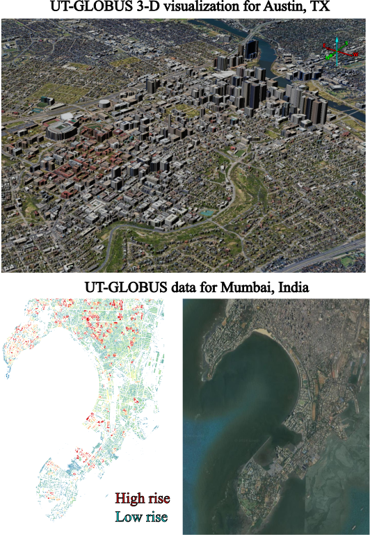
UT-GLOBUS_example.png
Files
(53.5 GB)
| Name | Size | Download all |
|---|---|---|
|
md5:dc64263cac8dbbfa9f77769667cc8096
|
4.6 GB | Preview Download |
|
md5:764f2a091a1c38ad2ebef5dcd8e1ed4a
|
6.4 GB | Preview Download |
|
md5:acf2215adf3fcba99b0bf0cb984f729e
|
16.4 GB | Preview Download |
|
md5:e8a9c03d07fc638fbcaf306159094131
|
127.0 kB | Download |
|
md5:0f57f29043bc45ca611ada74873fe15c
|
131.1 kB | Download |
|
md5:9e96f0a6514cb372901e0353dbb59a76
|
188.4 kB | Download |
|
md5:8672ed073453e9865d05322078281cb3
|
159.7 kB | Download |
|
md5:82e2d50b4432165a9483e50399b9adec
|
135.2 kB | Download |
|
md5:db6b4ea7a06e755aeba67c879c4a0010
|
131.1 kB | Download |
|
md5:5c75a19659143b6639c208bb0e7a1204
|
5.6 GB | Preview Download |
|
md5:0fe37a7edc8d75751a559330c5ec604a
|
280 Bytes | Preview Download |
|
md5:28354e7ef7e39553723ad9d5a3929b73
|
3.5 kB | Preview Download |
|
md5:ac9c7cdf507c7c159224696d48b0c484
|
6.0 GB | Preview Download |
|
md5:8132b74bdcb47ad98844cbc39a5fd8bd
|
14.6 GB | Preview Download |
|
md5:a7c363f49fb5a9e33cda2b8766d7e3f0
|
806.0 kB | Preview Download |
Additional details
Related works
- Is published in
- Journal article: 10.1038/s41597-024-03719-w (DOI)
Funding
- National Aeronautics and Space Administration
- Interdisciplinary Research in Earth Science (IDS) 80NSSC20K1262
- U.S. National Science Foundation
- U-Cube OAC-1835739
- National Aeronautics and Space Administration
- Interdisciplinary Research in Earth Science (IDS) 80NSSC20K1268
Software
- Repository URL
- https://github.com/texuslabut/UT-GLOBUS/tree/main/GLOBUS
- Programming language
- Python, Fortran