NOAA NCCOS Mesophotic and Deep Benthic Communities: Mapping, Ground-truthing, and Predictive Habitat Modeling: Priority areas suggested for restoration and protection of mesophotic and deep benthic communities injured by the Deepwater Horizon oil spill in the Gulf of Mexico, 2021-10-12 to 2021-11-05
Authors/Creators
-
1.
 NOAA National Centers for Coastal Ocean Science
- 2. Matt.Kendall@noaa.gov
- 3. bethany.williams@noaa.gov
- 4. ken.buja@noaa.gov
Contributors
Data manager:
Project member (3):
-
1.
NOAA National Centers for Coastal Ocean Science
- 2. nccos.data@noaa.gov
Description
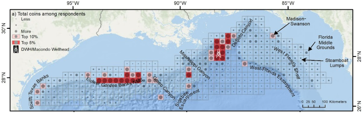
The National Oceanic and Atmospheric Administration (NOAA) National Centers for Coastal Ocean Science (NCCOS) developed a spatial framework, process, and online application (Buja and Christensen 2019) to identify information needs in the northern Gulf of Mexico to restore mesophotic and deep benthic communities (MDBC) affected by the Deepwater Horizon oil spill. Sixty-four participants from local federal, state, academic, and other institutions entered their priorities in an online participatory Geographic Information System (pGIS) using virtual coins to denote their priorities in 25 x 25 kilometer (km) grid cells overlaid on the study area. Grid cells with more coins were higher priorities than cells with fewer coins. Participants also reported why these locations were important and what data types were needed using a pre-set list of options. Results were compiled, summarized, and mapped to identify high priority areas, reasons for those priorities, and information needs. The largest concentrations of high priority cells were located in two groups, one in the vicinity of the Deepwater Horizon/Macondo wellhead site, and another along the topography associated with the Flower Garden Banks National Marine Sanctuary (FGBNMS). Isolated or smaller groups of high priority cells occurred elsewhere in the study region and included South Texas Banks, parts of the Mississippi, DeSoto, and Green Canyons, the northern edges of the Sigsbee and West Florida Escarpments, and also Madison-Swanson and Steamboat Lumps on the West Florida Shelf. Participants consistently selected (1) Protection or management, (2) Exploration to identify new MDBC areas and (3) Selection of monitoring sites as their top reasons (i.e., justifications) for prioritizing locations.
They also selected the following three items as their top data or requirement needs (1) Identification of species of corals and their local environments, (2) Delineations of large topographic features, and (3) Documentation of individual corals. This ESRI shapefile summarizes the results from the study. Identifying these high priority areas is among the first steps in planning the 5-year Implementation Phase of the MDBC portfolio. Specific locations for implementing project activities will be identified based on this analysis as well as additional information such as the size and depth of seafloor features, presently available data as determined through gap analysis, requirements for new data acquisitions including model resolution and accuracy, as well as available ship time and survey equipment.
Files
BrowseGraphic.png
Additional details
Related works
Dates
- Other
-
2021-10-12Start Date
- Other
-
2021-11-05End Date
References
- Kendall, M.S., B.L. Williams, K. Buja, and D. Dorfman. 2022. Priority Areas Suggested by Stakeholders for Restoration and Protection of Mesophotic and Deep Benthic Communities Injured by the Deepwater Horizon Oil Spill. NOAA Technical Memorandum NOS NCCOS 301. Silver Spring, MD. 31 pp. https://doi.org/10.25923/61r3-gk12
- DWH PDARP/PEIS. 2016. Deepwater Horizon oil spill: Final Programmatic Damage Assessment and Restoration Plan and Final Programmatic Environmental Impact Statement. Retrieved from http://www.gulfspillrestoration.noaa.gov/restoration-planning/gulf-plan December 2021.
- Buja, K., and J. Christensen. 2019. Spatial Prioritization Widget: A Tool to Identify Mapping Priorities. Available Online: https://coastalscience.noaa.gov/project/spatial-prioritization- widget/ (Accessed 26 June, 2019).
- NCCOS Project, Mesophotic and Deep Benthic Communities, https://coastalscience.noaa.gov/project/scientific-support-for-mesophotic-and- deep-benthic-community-restoration-in-the-gulf-of-mexico/
- Gulf Spill Restoration - Mesophotic and Deep Benthic Communities - Mapping, Ground- truthing, and Predictive Habitat Modeling, https://www.gulfspillrestoration.noaa.gov/project?id=234
- National Centers for Coastal Ocean Science. 2022. NOAA NCCOS Mesophotic and Deep Benthic Communities: Mapping, Ground-truthing, and Predictive Habitat Modeling: Priority areas recommended for restoration and protection of mesophotic and deep benthic communities in response to the Deepwater Horizon oil spill in the Gulf of Mexico, 2021-10- 12 to 2021-11-05. InPort Metadata Record. https://www.fisheries.noaa.gov/inport/item/66439
- Deepwater Horizon NRDA, https://www.gulfspillrestoration.noaa.gov/
- Open Ocean Trustee Implementation Group, https://www.gulfspillrestoration.noaa.gov/restoration-areas/open-ocean