Published August 11, 2017
| Version v1
Dataset
Open
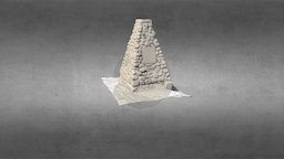
King Mountain Cairn (3M-grey) from SCENE 7.0
Description
Cairn and plaque marking the First Geodetic Survey Station in Canada.
More information here:
http://www.historicplaces.ca/en/rep-reg/place-lieu.aspx?id=14823
This was generated using a FARO X330 scanner and Scene 7.0.
Source: Objaverse 1.0 / Sketchfab
Files
thumb0.jpeg
Files
(120.5 MB)
| Name | Size | Download all |
|---|---|---|
|
md5:87dccc532e62011bbcd3f6870e6a3404
|
120.4 MB | Download |
|
md5:dd6cc8b35d39b629460eb3ea2615c412
|
90.8 kB | Preview Download |
|
md5:dc10a3136a005e955a0eaeea54fb03b9
|
42.3 kB | Preview Download |
|
md5:50265f479151647b73c3e55eb841f193
|
5.3 kB | Preview Download |
|
md5:8952d0fcc2e9ae73cf5fd35825a8a64f
|
1.0 kB | Preview Download |