Published May 20, 2016
| Version v1
Dataset
Open
Veit A. "Kirkjugarðurin", Koltur
Description
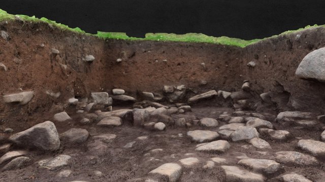
Veit A "Kirkjugarðinum", norðan fyri "Bønhúsið", Heimi í Húsi í Koltri. Endastøða, summari 2015. Veitin var 3D skrásett fyri hvørja flá, ið varð grivin burtur. Endamálið var at samanbera 3D skrásetngarnar við georadarmyndir, framleiddar av Sp/f Munin. 5 metrar long og 1,8 metrar breið *Trench A in the "Churchyard" north of the "Chapel" Heimi í Húsi, Koltur, Faroe Islands. Each context was 3D documented during the excavation. The aim was to compare the 3D documentation with ground penetrating radar (GPR) images, and to test the GPR method in Faroese archaeology. 1,8 x 5 meters* Model by Helgi D. Michelsen Source: Objaverse 1.0 / Sketchfab
Files
thumb0.jpeg
Files
(16.9 MB)
| Name | Size | Download all |
|---|---|---|
|
md5:f32a24ddf69eb63ab64b1af4220b41f3
|
16.6 MB | Download |
|
md5:b8aee93af66cdbcb3cf07a6c1bd95f50
|
28.1 kB | Preview Download |
|
md5:e53341661ba6fa678ee5ceb2bdb1aab8
|
3.4 kB | Preview Download |
|
md5:1847d45d787ea74c8bb30c612797110d
|
1.3 kB | Preview Download |
|
md5:db34e2aaae789e556f995221ed728924
|
10.2 kB | Preview Download |
|
md5:cb59a272b2fe962ac5b40ba5aebf6d56
|
52.0 kB | Preview Download |
|
md5:bf97473e3eb6eabffa530647af3b78b6
|
88.2 kB | Preview Download |
|
md5:72d975c6679690da2ea003fb78949923
|
116.9 kB | Preview Download |