Dynamic Land-Water Management Model for the Oudlandpolder - Belgium
Creators

- 1. Vlaamse Instelling voor Technologisch Onderzoek (VITO nv). Boeretang 200, 2400 Mol, Belgium.
- 2. Vlaamse Land Maatschappij
Description
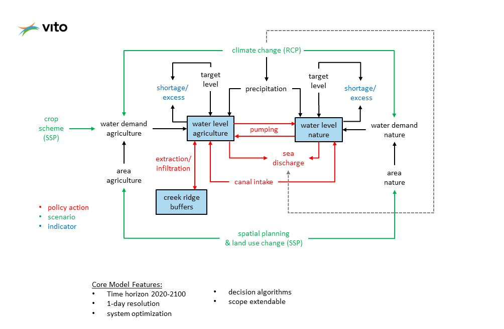
This System Dynamics model was developed together with the Flemish Land Agency (VLM) to obtain a high-level, systemic understanding of the mid- and long-term impacts of water management actions for the Oudlandpolder in Belgium in the framework of the new Spatial Implementation Plan, aimed at climate robust and balanced land and water management (see https://doi.org/10.5281/zenodo.7081821). The model is based on two artificial compartments, one for agriculture and one for nature, and driven by scenarios for climate change, land use and crop schemes. Water levels in the agriculture and nature compartment are optimized based on monthly target levels and day-to-day decisions on water management actions such as canal water intake, sea discharge and creek ridge water extraction or infiltration. The model uses a time horizon of 80 years (2020-2100) and a time step of 1 day, to align with the practice of water management decisions (such as the opening of sluices).
The model uses diverse data related to land use cover change, climate change, water management, and crop farming. Important data sources include: the Flemish Institute for Technological Research (VITO) for meteorological forecasts for different climate change scenarios, the Food and Agriculture Organization of the United Nations (FAO) for crop factors and the Flemish Land Agency (VLM) for water control parameters. Driving scenarios are based on the Shared-Social Economic Pathways (for crop schemes and land use patterns, see https://doi.org/10.5281/zenodo.7081500 ), the VITO RuimteModel for land use change (see https://vito.be/en/product/geodynamix-spatial-modelling-tools), RCP-based projections for temperature, potential evapotranpiration and precipitation, and related sea level projections obtained from Fox-Kemper, B., et al., 2021, Ocean, Cryosphere and Sea Level Change. In: Climate Change 2021: The Physical Science Basis. Contribution of Working Group I to the Sixth Assessment Report of the Intergovernmental Panel on Climate Change (Masson-Delmotte, V., P., et al. (eds.)). Cambridge University Press. In Press.
Notes
Files
773782 SD Model Oudlandpolder v35.zip
Files
(56.5 MB)
| Name | Size | Download all |
|---|---|---|
|
md5:fa840cf7c505d35c7a3118b47ccd392e
|
56.5 MB | Preview Download |
|
md5:4c02acafbb7d6d6e57bc0568d3395b09
|
40.5 kB | Preview Download |