Distribution of waterbirds along the Drugeon river, France
Authors/Creators

- 1. Chrono-environnement, Université de Franche-Comté
- 1. Université de Franche-Comté
Description
This dataset describes bird observations performed along the Drugeon river, France from 2006 to 2019.
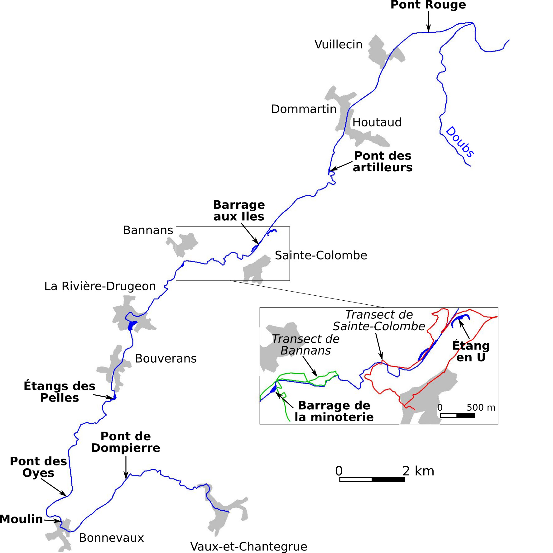
'Carte.jpg' Map of the study area. The box shows the location of the Bannans and the Sainte-Colombe transects. Village locations and the route of the river have been taken from 'BD Carto ', kindly provided for research by the National Geographical Institute, and modified on the basis of field observations.
'Mat sup 1 transects Drugeon synthèse_Zenodo.xlsx' since September 2006, two transects were carried out four times a fortnight,on foot in the early morning. All identified birds, by sight or by ear, were noted with special care to avoid double counting. The two transects are located in the downstream part of the Drugeon valley. The Bannans transect starts from the Drugeon diversion upstream from the Bannans flour mill and runs along the river downstream to the place called Mitray, with a lateral extension to the En Vau-Les-Aigues marsh located partly in the La Rivière-Drugeon village. This transect is approximately 5.4 km long, of which 1.4 km follow the river. It sampled the bird population of the river, the marshes more or less wooded with willows, birches and a few spruces, and the neighboring meadows and pastures. The flour mill dam provides a 3660 square meter body of water that is not flushed out because it is attached to a dwelling house. This is the only non-huntable wetland area along the two transects. The Sainte-Colombe transect starts from the village, crosses the mesophilic and then wet meadows to reach almost the downstream end of the Bannans transect. It then runs along the river in its undisturbed part to the Chaffois mill. The return to the village is via an agricultural path that crosses mesophilic and humid meadows, a marsh and a small wood of poplar and spruce trees. This transect is 8.6 km long including 2 km along the river. A U-shaped pond carved out of a marsh provides an open water surface of approximately 3400 square meters. It was also prospected during the transect.
'Mat sup 2 données brutes descente du Drugeon.xlsx' covers the censuses along the course of the Drugeon river from 2014 to 2019. Birds were recorded during a course carried out on foot along the river on a bank from the Dompierre bridge located between Vaux-et-Chantegrue and Bonnevaux villages to the Pont Rouge bridge next to Vuillecin village (29,2 km representing almost the entire course of the Drugeon river). Each year, the census was taken in sections during the second half of October, an average of one to one and a half months after the opening of the hunting season. Each waterbird observed was precisely located on a map and then plotted on Google Earth. Using Géoportail and field surveys, a precise description of the watercourse has been carried out on the whole of the prospected area: environment bordering each bank (forest, wooded marsh, herbaceous marsh, meadow, village), vegetation on each bank (continuous willow, megaphorbiaie with scattered willows, pure megaphorbiaie, phragmitaie, short herbaceous vegetation), width of the river, slope of the watercourse, status with respect to hunting (huntable zone, zone not huntable because located less than 150 m from homes and hunting reserve).
The figures of the following three files are computed from the two files above: Mat sup 1 and Mat sup 2:
'Mat sup 3 Down river walk.zip' Distribution and abundance 2014-2019 of the main waterbird species along the Drugeon river
'Mat sup 4 Hunting season onset.zip' Abundance of the Anatidae species on the Bannans and Sainte-Colombe transects according to the opening date of waterbird hunting
'Mat sup 5 Bannans transect.zip' Abundance of the Anatidae species on the Bannans and Sainte-Colombe transects according to the opening date of waterbird hunting
'TransectsDomi.kml' a kml file locating the Bannans and Sainte-Colombe transects (polylines).
Notes
Files
Carte.jpg
Files
(6.8 MB)
| Name | Size | Download all |
|---|---|---|
|
md5:655e11eaa48fcbc841c9b05ae51d1aba
|
308.6 kB | Preview Download |
|
md5:33f38ed127aeb6f0e256bc34a91a9567
|
577.8 kB | Download |
|
md5:9361de86d4ec380348fe40909fec220a
|
168.6 kB | Download |
|
md5:f24d642c923a9cc0c7f9e86a0d64d798
|
1.6 MB | Preview Download |
|
md5:b6ddb9a3bdc4f34fd6ed97f1e483952a
|
2.4 MB | Preview Download |
|
md5:6575faeca628c9dc3f5995fe131d5fd5
|
1.8 MB | Preview Download |
|
md5:2db6a20a51d025629eae25e3069a4e0f
|
8.6 kB | Download |
Additional details
References
- Michelat and Giraudoux (2022). Chasse aux oiseaux d'eau et Paysage de la peur dans un site Ramsar, le bassin du Drugeon. Nos Oiseaux. 69 (2) 111-136