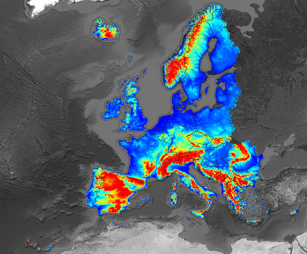
Continental Europe Digital Terrain Model at 30 m resolution based on GEDI and background layers
Authors/Creators

- 1. OpenGeoHub foundation
- 2. MultiOne
Description
Digital Terrain Model for Continental Europe based on the three publicly available Digital Surface Models and predicted using an Ensemble Machine Learning (EML). EML was trainined using GEDI level 2B points (column "elev.lowestmode"): about 7 million GEDI points were overlaid vs MERITDEM, AW3D30, GLO-30, EU DEM, GLAD canopy height, tree cover and surface water cover maps, then an ensemble prediction model was fitted using random forest, GLM with Lasso, Cubist and GLMnet, and used to predict most probable terrain height (bare earth). Input layers used to train the EML include:
- "lcv_bare.earth_glcf.landsat": UMD GLAD bare earth estimate for year 2010 based on Landsat time series,
- "dtm_elev.dsm_alos.aw3d": Digital Surface Model based on ALOS AW3D,
- "dtm_canopy.height_glad.umd": UMD GLAD canopy height for 2019 based on GEDI data,
- "dtm_elev.dsm_eudem.eea": Copernicus EU DEM based on the SRTM and ASTER DEMs,
- "hyd_surface.water_jrc.gswe": JRC Global Surface Water Explorer surface water probability based on the Landsat time-series,
- "lcv_landcover.12_pflugmacher2019": land cover map of Europe at 30 based on Pflugmacher et al. (2019),
- "lcv_tree.cover_umd.landsat_2000": forest tree cover for year 2000 based on the Global Forest Change data,
- "lcv_tree.cover_umd.landsat_2010": forest tree cover for year 2010 based on the Global Forest Change data,
Detailed processing steps can be found here. Read more about the processing steps here. Training data set can be obtained in the file "gedi_elev.lowestmode_2019_eumap.RDS". Summary results of the model training (mlr::makeStackedLearner) report:
Variable: elev_lowestmode
R-square: 1
Fitted values sd: 353
RMSE: 6.45

Ensemble model:
Call:
stats::lm(formula = f, data = d)

Residuals:
    Min      1Q  Median      3Q     Max
-78.880  -2.474   0.523   2.817 223.228

Coefficients:
               Estimate Std. Error t value Pr(>|t|)
(Intercept)    2.086691   0.078138   26.70   <2e-16 ***
regr.ranger    0.586053   0.001123  522.01   <2e-16 ***
regr.glmnet    3.108060   0.101530   30.61   <2e-16 ***
regr.cvglmnet -3.104559   0.101658  -30.54   <2e-16 ***
regr.cubist    0.404570   0.001146  353.10   <2e-16 ***
---
Signif. codes:  0 '***' 0.001 '**' 0.01 '*' 0.05 '.' 0.1 ' ' 1

Residual standard error: 6.448 on 6756251 degrees of freedom
Multiple R-squared:  0.9997,	Adjusted R-squared:  0.9997
F-statistic: 5.051e+09 on 4 and 6756251 DF,  p-value: < 2.2e-16
Which indicates that the elevation errors are in average (2/3rd of pixels) between +2-3 m. The variable importance based on Random Forest package ranger shows:
Variable importance:
               variable   importance
4   eu_MERITv1.0.1_30m_ 339179872235
2         eu_GLO30_30m_ 195444455910
1     eu_AW3Dv2012_30m_ 177308698430
3            eu_dem25m_ 118993789329
9 eu_canopy_height_30m_   4605735928
7             bare2010_   3360985239
6        treecover2010_    801394531
8        treecover2000_    314790601
The output predicted terrain model includes the following two layers:
- "dtm_elev.lowestmode_gedi.eml_m": mean estimate of the terrain elevation,
- "dtm_elev.lowestmode_gedi.eml_md": standard deviation of the independently fitted stacked predictors quantifying the prediction uncertainty,
The predicted elevations are based on the GEDI data hence the reference water surface (WGS84 ellipsoid) is about 43 m higher than the sea water surface for a specific EU country. All GeoTIFFs were prepared using Integer format (elevations rounded to 1 m) and have been converted to Cloud Optimized GeoTIFFs using GDAL.
Disclaimer: The output DTM still shows forest canopy (overestimation of the terrain elevation) and has not been hydrologically corrected for spurious sinks and similar. This data set is continuously updated. To report a bug or suggest an improvement, please visit here. To access DTM derivatives at 30-m, 100-m and 250-m please visit here. To register for updates please subscribe to: https://twitter.com/HarmonizerGeo.
Notes
Files
001_preview_EU_DTM.png
Files
(45.3 GB)
| Name | Size | |
|---|---|---|
|
md5:0f960837d2385943460e1721a82ba131
|
1.4 MB | Preview Download |
|
md5:b7136655458433c798b064d22d089b69
|
3.7 GB | Preview Download |
|
md5:229afa70b0878282f04c2a3b6a701876
|
9.9 GB | Preview Download |
|
md5:1c71a8782a4da623e6883d041b89f0b3
|
8.0 GB | Preview Download |
|
md5:e1e4877750350b2e4ce6b481a92a5065
|
616.9 MB | Preview Download |
|
md5:00a99f8bce1a2011f835090df6e852d9
|
7.9 GB | Preview Download |
|
md5:886793e761bfeb0d92e8d5d75992aa48
|
2.4 GB | Preview Download |
|
md5:7219b45acbd149ae1dcaa30d4d3669f2
|
1.0 GB | Preview Download |
|
md5:7e3e3e2e398fa5fa9594a930d6e1095e
|
1.5 GB | Download |
|
md5:af37fef0c0e8ae693888c5bc737f90a5
|
998.2 MB | Preview Download |
|
md5:a4554a120b89bf3230b8e1373ca0c7b8
|
3.5 GB | Preview Download |
|
md5:e292d4800e8c8c4df40dea4b7f756478
|
1.3 GB | Preview Download |
|
md5:31ac1244c16de3a59c3e7f8b25769273
|
4.3 GB | Preview Download |
Additional details
Related works
- Is supplement to
- Dataset: 10.5281/zenodo.4486135 (DOI)
- Is supplemented by
- Dataset: 10.5281/zenodo.4058447 (DOI)
References
- Bischl, B., Lang, M., Kotthoff, L., Schiffner, J., Richter, J., Studerus, E., ... & Jones, Z. M. (2016). mlr: Machine Learning in R. The Journal of Machine Learning Research, 17(1), 5938-5942.
- Hansen, M. C., Potapov, P. V., Moore, R., Hancher, M., Turubanova, S. A., Tyukavina, A., ... & Kommareddy, A. (2013). High-resolution global maps of 21st-century forest cover change. science, 342(6160), 850-853.
- Pekel, J. F., Cottam, A., Gorelick, N., & Belward, A. S. (2016). High-resolution mapping of global surface water and its long-term changes. Nature, 540(7633), 418-422.
- Pflugmacher, D., Rabe, A., Peters, M., & Hostert, P. (2019). Mapping pan-European land cover using Landsat spectral-temporal metrics and the European LUCAS survey. Remote sensing of environment, 221, 583-595.
- Potapov, P., X. Li, A. Hernandez-Serna, A. Tyukavina, M.C. Hansen, A. Kommareddy, A. Pickens, S. Turubanova, H. Tang, C.E. Silva, J. Armston, R. Dubayah, J. B. Blair, M. Hofton (2020) Mapping and monitoring global forest canopy height through integration of GEDI and Landsat data. In review
- Takaku, J., & Tadono, T. (2017). Quality updates of 'AW3D'global DSM generated from ALOS PRISM. In 2017 IEEE International Geoscience and Remote Sensing Symposium (Igarss) (pp. 5666-5669). IEEE.