iSDAsoil: soil extractable Phosphorus for Africa predicted at 30 m resolution at 0-20 and 20-50 cm depths
Creators

- 1. EnvirometriX
- 2. Innovative Solutions for Decision Agriculture Ltd (iSDA)
- 3. MultiOne
- 4. University of Belgrade
- 5. Rothamsted Research
- 6. World Agroforestry (ICRAF)
Description
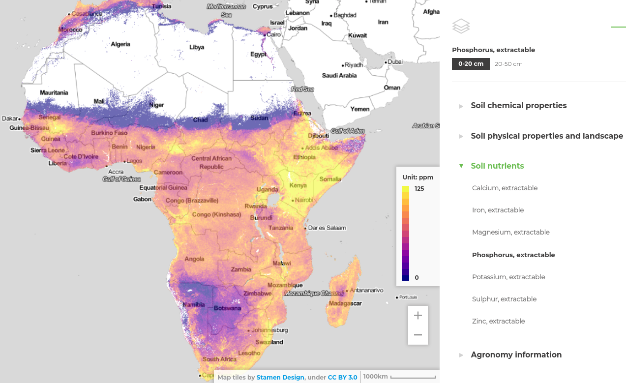
iSDAsoil dataset soil extractable Phosphorus (P) log-transformed predicted at 30 m resolution for 0–20 and 20–50 cm depth intervals. Data has been projected in WGS84 coordinate system and compiled as COG. Predictions have been generated using multi-scale Ensemble Machine Learning with 250 m (MODIS, PROBA-V, climatic variables and similar) and 30 m (DTM derivatives, Landsat, Sentinel-2 and similar) resolution covariates. For model training we use a pan-African compilations of soil samples and profiles (iSDA points, AfSPDB, and other national and regional soil datasets). Cite as:
Hengl, T., Miller, M.A.E., Križan, J. et al. African soil properties and nutrients mapped at 30 m spatial resolution using two-scale ensemble machine learning. Sci Rep 11, 6130 (2021). https://doi.org/10.1038/s41598-021-85639-y
To open the maps in QGIS and/or directly compute with them, please use the Cloud-Optimized GeoTIFF version.
Layer description:
- sol_log.p_mehlich3_m_30m_*..*cm_2001..2017_v0.13_wgs84.tif = predicted soil extractable Phosphorus mean value,
- sol_log.p_mehlich3_md_30m_*..*cm_2001..2017_v0.13_wgs84.tif = predicted soil extractable Phosphorus model (prediction) errors,
Model errors were derived using bootstrapping: md is derived as standard deviation of individual learners from 5-fold cross-validation (using spatial blocking). The model 5-fold cross-validation (mlr::makeStackedLearner) for this variable indicates:
Variable: log.p_mehlich3
R-square: 0.486
Fitted values sd: 0.687
RMSE: 0.707

Random forest model:
Call:
stats::lm(formula = f, data = d)

Residuals:
    Min      1Q  Median      3Q     Max
-3.2892 -0.3942 -0.0637  0.2614  4.9466

Coefficients:
               Estimate Std. Error t value Pr(>|t|)
(Intercept)    3.378801   3.143200   1.075    0.282
regr.ranger    0.861655   0.011099  77.631  < 2e-16 ***
regr.xgboost   0.066139   0.013091   5.052 4.38e-07 ***
regr.cubist    0.157674   0.008886  17.744  < 2e-16 ***
regr.nnet     -1.649621   1.442240  -1.144    0.253
regr.cvglmnet  0.013628   0.010407   1.310    0.190
---
Signif. codes:  0 '***' 0.001 '**' 0.01 '*' 0.05 '.' 0.1 ' ' 1

Residual standard error: 0.7066 on 53493 degrees of freedom
Multiple R-squared:  0.486,	Adjusted R-squared:  0.486
F-statistic: 1.012e+04 on 5 and 53493 DF,  p-value: < 2.2e-16
To back-transform values (y) to ppm use the following formula:
ppm = expm1( y / 10 )To submit an issue or request support please visit https://isda-africa.com/isdasoil
Notes
Files
001_africa_soil_extr_phosphorus_30m.png
Files
(24.6 GB)
| Name | Size | Download all |
|---|---|---|
|
md5:5df8ba53ee1d17b4bd1c26b142cee90c
|
633.6 kB | Preview Download |
|
md5:b0861968ca1f87743df858b41b552d49
|
5.4 kB | Preview Download |
|
md5:2dceaadceacc6b46c8e2c856b46f84f5
|
7.8 GB | Preview Download |
|
md5:64e587e9d8e3ca76717df3bc6c4cfdeb
|
7.8 GB | Preview Download |
|
md5:c3a5e794c40eb7407056a54a5ee8ad48
|
4.5 GB | Preview Download |
|
md5:57f4e63d81c40de6653e88a782cfce90
|
4.4 GB | Preview Download |
Additional details
References
- Hengl, T., Leenaars, J. G., Shepherd, K. D., Walsh, M. G., Heuvelink, G. B., Mamo, T., ... & Wheeler, I. (2017). Soil nutrient maps of Sub-Saharan Africa: assessment of soil nutrient content at 250 m spatial resolution using machine learning. Nutrient Cycling in Agroecosystems, 109(1), 77-102.
- Hengl, T., MacMillan, R.A., (2019). Predictive Soil Mapping with R. OpenGeoHub foundation, Wageningen, the Netherlands, 370 pages, www.soilmapper.org, ISBN: 978-0-359-30635-0.
- Leenaars, J. G. B. (2014). Africa Soil Profiles Database, Version 1.2. A compilation of georeferenced and standardised legacy soil profile data for Sub-Saharan Africa (with dataset). Africa Soil Information Service (AfSIS) project (No. 2014/03). ISRIC-World Soil Information.
- Vågen, T. G., Winowiecki, L. A., Tondoh, J. E., Desta, L. T., & Gumbricht, T. (2016). Mapping of soil properties and land degradation risk in Africa using MODIS reflectance. Geoderma, 263, 216-225.