Published September 30, 2018
| Version v1.0
Dataset
Open
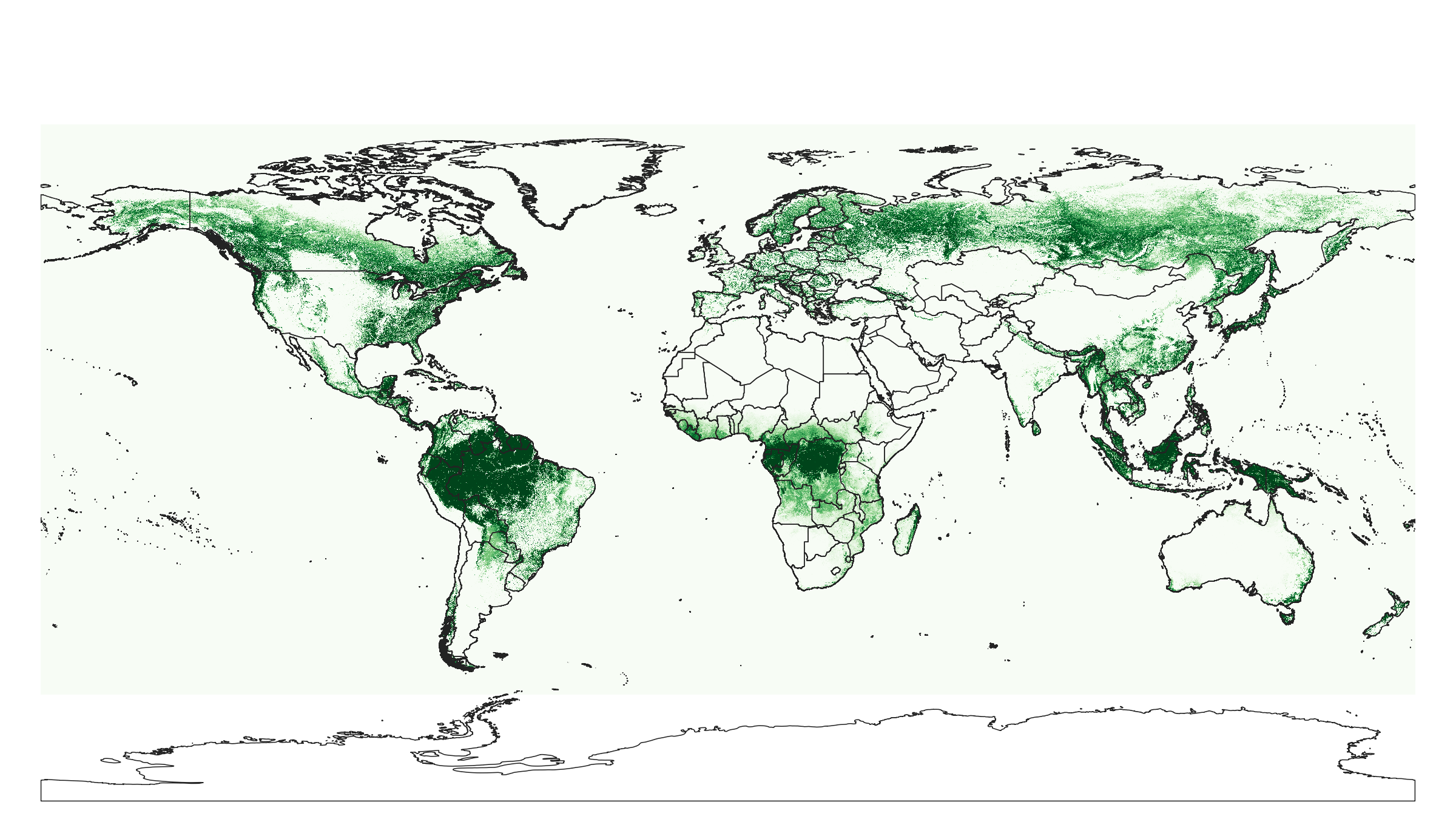
Landsat bands (cloud free), tree cover (2000, 2010), bare-ground and surface water occurrence at 250 m based on GlobalForestWatch and USGS

Description
Landsat bands (cloud free) and tree cover (2000) based on Hansen et al. (2013), global surface water occurrence based on Pekel at al. (2016), and tree cover and bare-ground cover (2010) based the USGS land cover mapping projects (University of Maryland, Department of Geographical Sciences and USGS). All layers resampled to spatial resolution 1/480 d.d. (about 250 m) using gdalwarp with "average" resampling. Antarctica is not included. Original layers are available at 30 m resolution.
If you discover a bug, artifact or inconsistency in the maps, or if you have a question please use some of the following channels:
- Technical issues and questions about the code: https://gitlab.com/openlandmap/global-layers/issues
- General questions and comments: https://disqus.com/home/forums/landgis/
All files internally compressed using "COMPRESS=DEFLATE" creation option in GDAL. File naming convention:
- lcv = theme: land cover,
- bareground = variable: occurrence of bareground,
- landsat.usgs = determination method: Landsat landcover at 30 m resolution project (https://landcover.usgs.gov/glc/),
- p = probability or fraction,
- 250m = spatial resolution / block support: 250 m,
- s0..0cm = vertical reference: land surface,
- 2010..2010 = time reference: year 2010,
- v1.0 = version number: 1.0,
Files
lcv_bareground_usgs.landsat_p_250m_s0..0cm_2010_v1.0.tif
Files
(48.7 GB)
| Name | Size | Download all |
|---|---|---|
|
md5:b203765e6b81723f18cc1e49b497f282
|
3.6 GB | Preview Download |
|
md5:6f997acb302ec51f89cf497cceede1d4
|
6.6 GB | Preview Download |
|
md5:c5d8da515220503c24b005ea400a8cfe
|
6.4 GB | Preview Download |
|
md5:e6b2628a7223945f685e5b5762ab0872
|
6.5 GB | Preview Download |
|
md5:c209792eea8c11f14c01982aab02df03
|
7.0 GB | Preview Download |
|
md5:30b7a36be40443f5a0754b9b5a9ad0e0
|
7.4 GB | Preview Download |
|
md5:d5f54e3533165c9459cc9ff584943cb1
|
2.4 GB | Preview Download |
|
md5:37cdd2613fbe633dcdfcdfc077c62027
|
2.4 GB | Preview Download |
|
md5:17c3d317f9fe035c94e39be4dd1d1a41
|
3.9 GB | Preview Download |
|
md5:ff906f7c39ae34e5c003bf2b87d92ee5
|
1.2 MB | Preview Download |
|
md5:b069aee361aa3c029e721dde13cbe02e
|
1.4 GB | Preview Download |
|
md5:d6a594363f3bf2cecbda615047784875
|
627.7 kB | Preview Download |
|
md5:65868a7761c55a58e1c24fd9020ae7f8
|
1.2 GB | Preview Download |
Additional details
References
- Hansen, M. C., P. V. Potapov, R. Moore, M. Hancher, S. A. Turubanova, A. Tyukavina, D. Thau, S. V. Stehman, S. J. Goetz, T. R. Loveland, A. Kommareddy, A. Egorov, L. Chini, C. O. Justice, and J. R. G. Townshend. 2013. "High-Resolution Global Maps of 21st-Century Forest Cover Change." Science 342 (15 November): 850–53. Data available on-line from: http://earthenginepartners.appspot.com/science-2013-global-forest.
- Pekel, J. F., Cottam, A., Gorelick, N., & Belward, A. S. (2016). High-resolution mapping of global surface water and its long-term changes. Nature, 540(7633), 418.