Published March 22, 2024
| Version v1
Dataset
Open
UAV-based colour-infrared orthomosaics and digital elevation models of basalts and rock glaciers on Disko Island, West Geenland

- 1. Technical University of Berlin
- 2. Geological Survey of Denmark and Greenland
Description
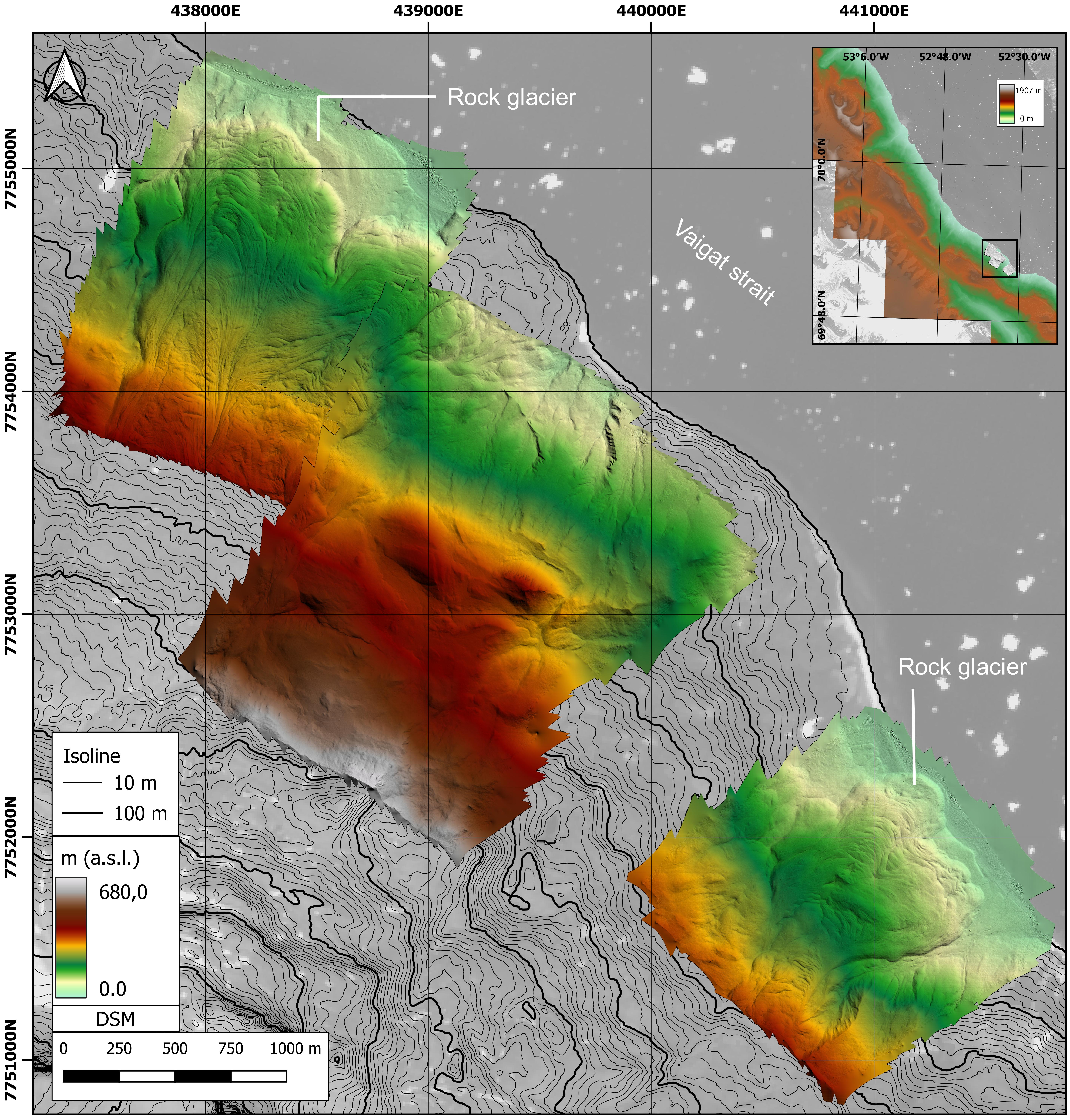
This data set contains multispectral surveys conducted with an unoccupied aerial vehicle over rock glaciers and steep mafic outcrops (intrusive and flood volcanics) near the coastline of Disko Island.
- Acquisition date: 07.08.2019 – 10.08.2019
- Location: Illukunnguaq, Disko Island, Greenland
- UAV: SenseFly eBee Plus
- Flight altitude above ground level: >100m
- Image Overlap forward/side: various
- Camera: Parrot Sequoia multispectral
- EPSG: 32622
- Center coordinates: 69.885277°N, -52.577724°E
- Flight mode: automatic flight plan
Data products:
- Orthomosaic colour-infrared, 10-16 cm pixel resolution
- Colour-infrared spectral bands: 790nm, 660nm, 550nm
- DEM, 20-30cm pixel resolution
- Data coverage: approx. 5500 x 2500 m
- Elevation profile: 20-680m
- Processing in Agisoft Metashape
Additional data supplement for article:
Barnes, E. (2020). Assessment of Drone-Borne Multispectral Mapping in the Exploration of Magmatic Ni-Cu Sulphides–an Example from Disko Island, West Greenland.
URN: urn:nbn:se:uu:diva-418858
MULSEDRO field campaign was conducted under scientific survey licence (VU-00158-2019) within mineral exploration licence MEL 2018-16 by Blue Jay Mining PLC. This research has been supported by the project MULSEDRO, funded by HZDR-HIF & EITRawMaterials (project ID 16193) and the European Union.
Files
Overview-map_Illukunnguaq_sequoia_DSM.jpg
Files
(6.1 GB)
| Name | Size | Download all |
|---|---|---|
|
md5:5a306b2fa62e8f83bdcf7e47a67cd7dd
|
268.1 MB | Preview Download |
|
md5:41a025996228203ae4038a7ee6e3e533
|
3.1 GB | Preview Download |
|
md5:4e3884b673474621af1fea68497042ad
|
1.4 GB | Preview Download |
|
md5:4cc74753b80ab1d0ad3626c90b5ffe04
|
219.9 MB | Preview Download |
|
md5:437028886835e9bb6bb2241d48fada5e
|
1.1 GB | Preview Download |
|
md5:3cbf0ff3eceff2c630fe364902dbadd7
|
94.5 MB | Preview Download |
|
md5:73f5cf3931a36d57f3969ba760080fdd
|
2.2 MB | Preview Download |
|
md5:38f90c870fe010dc04a1f3f204cbbf84
|
3.4 MB | Preview Download |
Additional details
Related works
- Documents
- Thesis: 1650-6553 (ISSN)
- Is supplement to
- Publication: 10.5194/se-13-793-2022 (DOI)
Dates
- Collected
-
2019-08-07Data collection