Gróthústangi, Koltur
Description
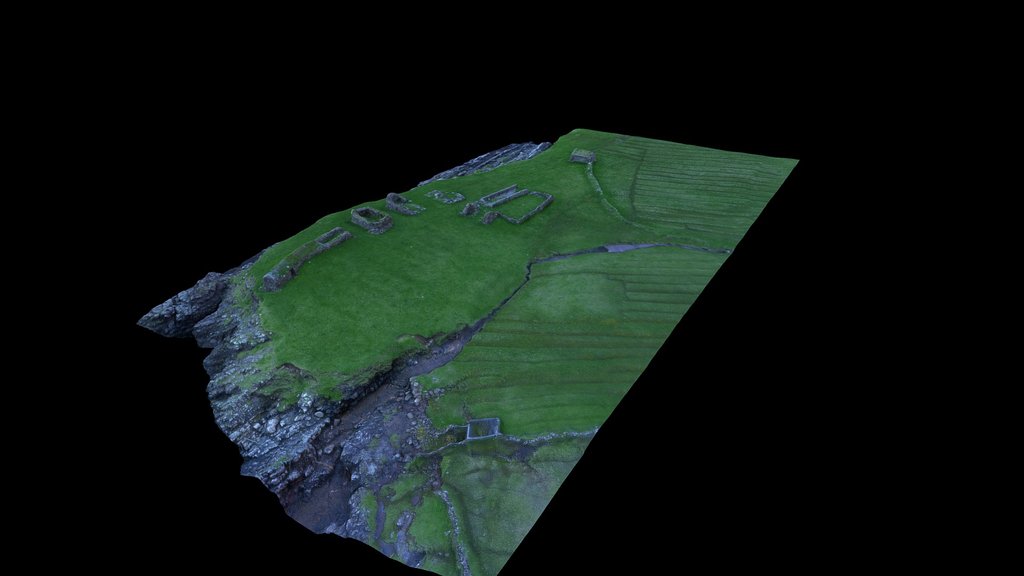
Gróthústangi er nevndur eftir gróthúsunum, sum har standa. Hesi eru øll úthús, sum standa í framhaldi av hvørjum øðrum heilt út á tangan. Tað langa gróthúsið, eitt sindur kreppt, ið stendur ytst, varð nýtt at turka fisk og korn og at goyma rekavið og torv. Í Koltri eru eingir torvheiðar, og frá gamlari tíð varð torvið til brenni skorið í Syðradali á Streymoy, seinni í Skopun á Sandoy, haðani tað varð ført við báti. Koltur is one of the smallest inhabited island of the 18 islands that constitute the Faroe Islands. The buildings are especially interesting as a national heritage, as they bear references to the Nordic architectural development. The building tradition is most pronounced in the different stone outhouses like here at Gróthústangi, where the stony walls carry the turf roof, and a very modest amount of wood has been used. By the old grain cultivation methods, the infield area is divided into arable strips, that make the landscape appear as the teeth of a saw. Model by Helgi D. Michelsen Source: Objaverse 1.0 / Sketchfab
Files
thumb0.jpeg
Files
(39.9 MB)
| Name | Size | Download all |
|---|---|---|
|
md5:480cc74ffb65777db2d655571ca22f10
|
39.7 MB | Download |
|
md5:fc0de186371746f65b6b03ef67d44ea8
|
177.2 kB | Preview Download |
|
md5:cfc346d0d406302a2f13fa58dafe65dc
|
46.2 kB | Preview Download |
|
md5:e21c83be33702f21438a95da438dff35
|
24.2 kB | Preview Download |
|
md5:2c8c3e21a8d8033626a3041b4a97a1e2
|
4.0 kB | Preview Download |
|
md5:d22e6de2fd38facfdddc954ae1998392
|
743 Bytes | Preview Download |