Hcropland30: A hybrid 30-m global cropland map by leveraging global land cover products and Landsat data based on a deep learning model
Authors/Creators
-
1.
 Central China Normal University
-
2.
Huazhong Agricultural University
-
3.
International Food Policy Research Institute
-
4.
International Institute for Applied Systems Analysis
-
5.
Kent State University
Description
Hcropland30:A 30-m global cropland map by leveraging global land cover products and Landsat data based on a deep learning model
***Please note this dataset is undergoing peer review***
Version: 1.0
Authors: Qiong Hu a, 1, Zhiwen Cai b, 1, Liangzhi You c, d, Steffen Fritz e, Xinyu Zhang c, He Yin f, Haodong Weic, Jingya Yang g, Zexuan Li a, Qiangyi Yu g, Hao Wu a, Baodong Xu b *, Wenbin Wu g, *
a Key Laboratory for Geographical Process Analysis & Simulation of Hubei Province/College of Urban and Environmental Sciences, Central China Normal University, Wuhan 430079, China
b College of Resources and Environment, Huazhong Agricultural University, Wuhan 430070, China
c Macro Agriculture Research Institute, College of Plant Science and Technology, Huazhong Agricultural University, Wuhan 430070, China
d International Food Policy Research Institute, 1201 I Street, NW, Washington, DC 20005, USA
e Novel Data Ecosystems for sustainability Research Group, International Institute for Applied Systems Analysis (IIASA), Schlossplatz 1, Laxenburg A-2361, Austria
f Department of Geography, Kent State University, 325 S. Lincoln Street, Kent, OH 44242, USA
g State Key Laboratory of Efficient Utilization of Arid and Semi-arid Arable Land in Northern China, the Institute of Agricultural Resources and Regional Planning, Chinese Academy of Agricultural Sciences, Beijing 100081, China
Introduction
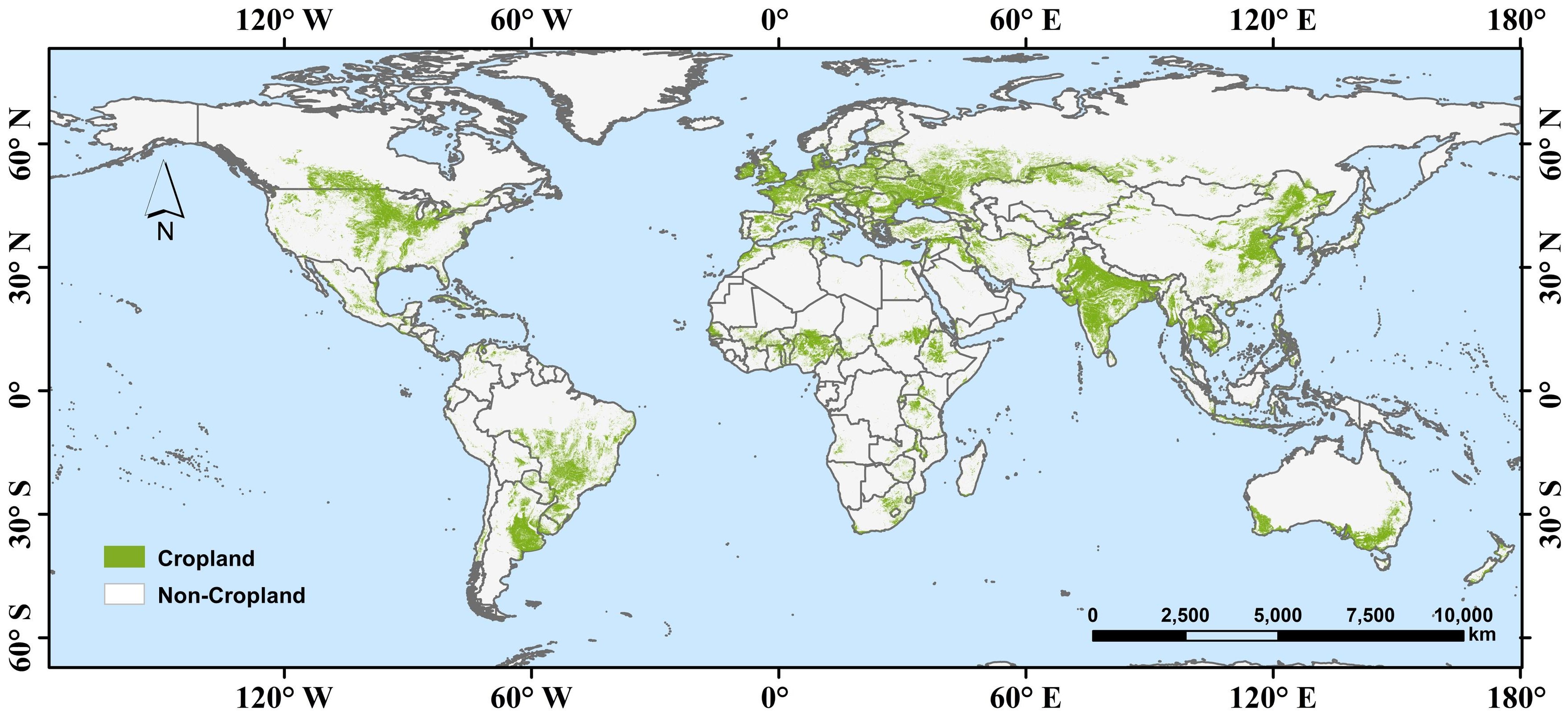
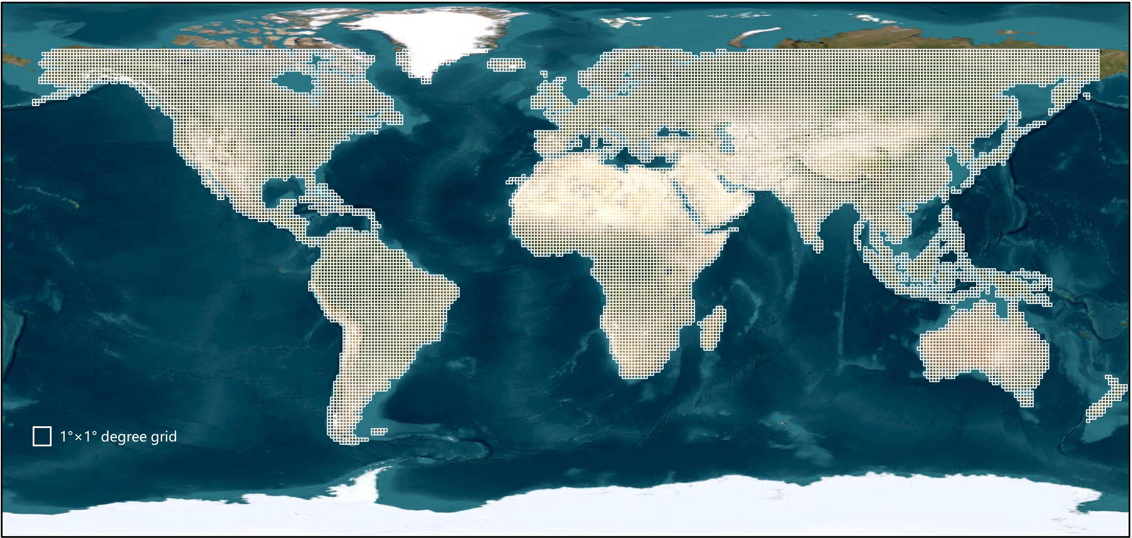
We are pleased to introduce a comprehensive global cropland mapping dataset (named Hcropland30) in 2020, meticulously curated to support a wide range of research and analysis applications related to agricultural land and environmental assessment. This dataset encompasses the entire globe, divided into 16,284 grids, each measuring an area of 1°×1°. Hcropland30 was produced by leveraging global land cover products and Landsat data based on a deep learning model. Initially, we established a hierarchal sampling strategy that used the simulated annealing method to identify the representative 1°×1° grids globally and the sparse point-level samples within these selected 1°×1°grids. Subsequently, we employed an ensemble learning technique to expand these sparse point-level samples into the densely pixel-wise labels, creating the area-level 1°×1° cropland labels. These area-level labels were then used to train a U-Net model for predicting global cropland distribution, followed by a comprehensive evaluation of the mapping accuracy.
Dataset
1. Hcropland30: A hybrid 30-m global cropland map in 2020
****Data format: GeoTiff
****Spatial resolution: 30 m
****Projection: EPSG: 4326 (WGS84)
****Values: 1 denotes cropland and 0 denotes non-cropland
The dataset has been uploaded in 16,284 tiles. The extent of each tile can be found in the file of “Grids.shp”. Each file is named according to the grid’s Id number. For example, “000015.tif” corresponds to the cropland mapping result for the 15-th 1°×1° grid. This systematic naming convention ensures easy identification and retrieval of the specific grid data.
2. 1°×1° Grids: This file contains all 16,284 1°×1° grids used in the dataset. The vector file includes 18 attribute fields, providing comprehensive metadata for each grid. These attributes are essential for users who need detailed information about each grid’s characteristics.
****Data format: ESRI shapefile
****Projection: EPSG: 4326 (WGS84)
****Attribute Fields:
Id: The grid’s ID number.
area: The area of the grid.
mode: Indicates the representative sample grid.
climate: The climate type the grid belongs to.
dem: Average DEM value of the grid.
ndvi_s1 to ndvi_s4: Average NDVI values for four seasons within the grid.
esa, esri, fcs30, fromglc, glad, globeland30: Proportion of cropland pixels of different publicly available cropland products.
inconsistent: Proportion of inconsistent pixels within the grid according to different public cropland products.
hcropland30: Proportion of cropland pixels of our Hcropland30 dataset.
3. Samples: The selected representative pixel-level samples, including 32,343 cropland and 67657 non-cropland samples. The category information of each sample was determined based on visual interpretation on Google Earth image and three-year NDVI time series curves from 2019-2021.
****Data format: ESRI shapefile
****Projection: EPSG: 4326 (WGS84)
****Attribute Fields:
type: 1 denotes cropland sample and 0 denotes non-cropland sample.
Citation
If you use this dataset, please cite the following paper:
Hu, Q., Cai, Z., You, L., Fritz, S., Zhang, X., Yin, H., Wei, H., Yang, J., Li, Z., Yu, Q., Wu, H., Xu, B., Wu, W. (2024). Hcropland30: A 30-m global cropland map by leveraging global land cover products and Landsat data based on a deep learning model, Remote Sensing of Environment, submitted.
License
The data is licensed under Creative Commons Attribution 4.0 International (CC BY 4.0).
Disclaimer
This dataset is provided as-is, without any warranty, express or implied. The dataset author is not
responsible for any errors or omissions in the data, or for any consequences arising from the use
of the data.
Contact
If you have any questions or feedback regarding the dataset, please contact the dataset author
Qiong Hu (huqiong@ccnu.edu.cn)
Files
global_cropland.jpg
Files
(2.3 GB)
| Name | Size | Download all |
|---|---|---|
|
md5:63c419cd58e2a15349b74fe532d69380
|
788.2 kB | Preview Download |
|
md5:3d254a0bc22cadf8d715d9a0f0e1b3ce
|
3 Bytes | Download |
|
md5:e6ff7df0b2e5893827720e2e66393218
|
6.2 MB | Download |
|
md5:df6fce01af2a2de8845eb7928307cbd8
|
1.6 MB | Preview Download |
|
md5:c742bee3d4edfc2948a2ad08de1790a5
|
145 Bytes | Download |
|
md5:8ae8ae168baf3a9f74e6ed8fb3ad995d
|
2.2 MB | Download |
|
md5:25f3213d211d92243cf95f22567fef01
|
130.4 kB | Download |
|
md5:e3b7d41b1974ebf01cf8e54daec63c4a
|
2.3 GB | Preview Download |
|
md5:dbadf2a839aedc1136f1b56997266735
|
22.6 kB | Download |
|
md5:0e4bb4efc30ec129e5003a18ea2103cf
|
10 Bytes | Download |
|
md5:068e3b03f7cec32411ba937791b66e11
|
9.1 MB | Download |
|
md5:c742bee3d4edfc2948a2ad08de1790a5
|
145 Bytes | Download |
|
md5:ade91915db53eb37e15a8d57573fa779
|
2.8 MB | Download |
|
md5:4d9f904fd44e09b476deb0b425f5d0c5
|
800.1 kB | Download |