Combining Novel High Resolution Remote Sensing and In Situ data for Monitoring the High Arctic Tundra
Authors/Creators

- 1. Institute of Geosciences and Earth Resources, National Research Council of Italy
- 2. Institute of Geoscience and Earth Resources, National Council of Research of Italy
- 3. Jacob Blaustein Institute for Desert Research, Ben Gurion University of the Negev, Israel
- 4. Institute of Geography and Spatial Planning, University of Lisbon (PT)
Description
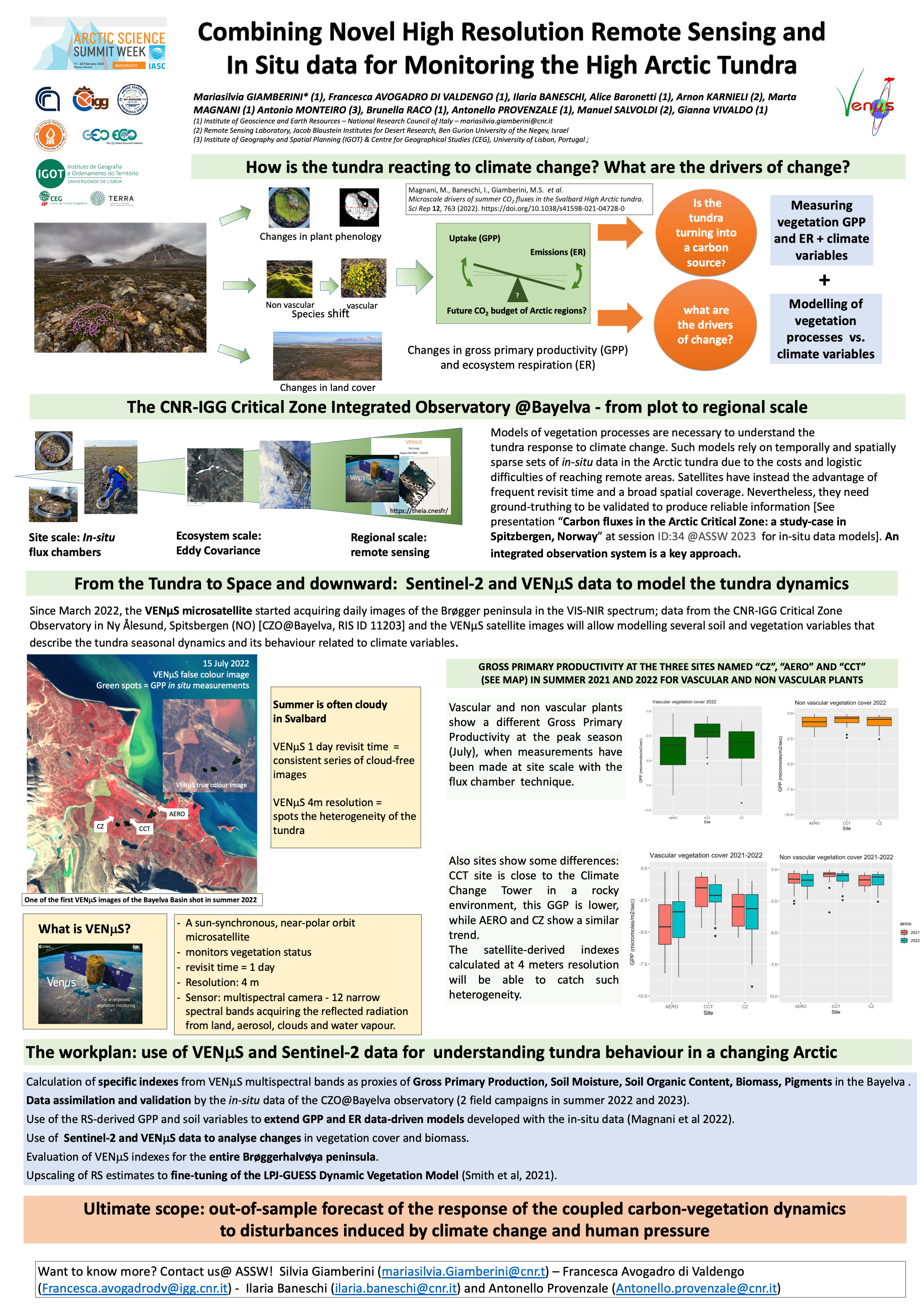
This poster has been presented at the 2023 ASSW conference in Vienna, Austria, and describes the ongoing activities aimed at extracting GGP indexes of the tundra vegetation in Svalbard (NO) using the micro satellite VENmS and in situ- measurements of GPP for validation.
Satellite data are particularly valuable in the High Arctic, where acquiring in situ data is particularly challenging. Such data in the VIS-NIR spectrum allow the assessment of the tundra soil-vegetation dynamics and in particular the spatiotemporal changes in vegetation biomass and the estimate of vegetation gross primary productivity (GPP).
Due to the limited number of summer cloud free days during summer in such environment, the 1-day revisit time of the new experimental VENμS satellite operating in the VIS-NIR spectrum (https://venus.cnes.fr/en/VENUS/index.htm) is a significant advantage. Moreover, the 4 meters resolution of VENμS may successfully capture the tundra heterogeneity.
In this work we present the preliminary results of the summer 2022 acquisition of VENμS images on the Brøgger peninsula in Svalbard (NO) compared with In Situ GPP and climatic variables measured in the tundra near Ny Ålesund. Our final aim at the end of at least two years acquisition is to develop new indices specific for the tundra for (a) assessing GPP and vegetation phenology and (b) exploiting the four VENµS red-edge bands for calculating several other specific vegetation indices. VENμS data and derived products will be open and respond to FAIR principles. Moreover, through VENµS data, we will have the opportunity to compare the spatial extent and vegetation biomass between VENµS and Sentinel-2 derived products and to generalise the results in other remote sites of the Brøegger peninsula.
Files
Giamberini_.Combining Novel High Resolution Remote Sensing and In Situ data for Monitoring the High Arctic Tundra.png
Files
(4.6 MB)
| Name | Size | Download all |
|---|---|---|
|
md5:6685cd117fec9ae766b188ba0689c936
|
4.6 MB | Preview Download |