Published September 8, 2020
| Version V3.0.1
Dataset
Open
Copernicus Global Land Service: Land Cover 100m: collection 3: epoch 2019: Globe
Authors/Creators

- 1. VITO NV
- 2. IIASA
- 3. Wageningen University
Description
Near real time epoch 2019 from the Collection 3 of annual, global 100m land cover maps.
Other available epochs: 2015 2016 2017 2018
Produced by the global component of the Copernicus Land Service, derived from PROBA-V satellite observations and ancillary datasets.
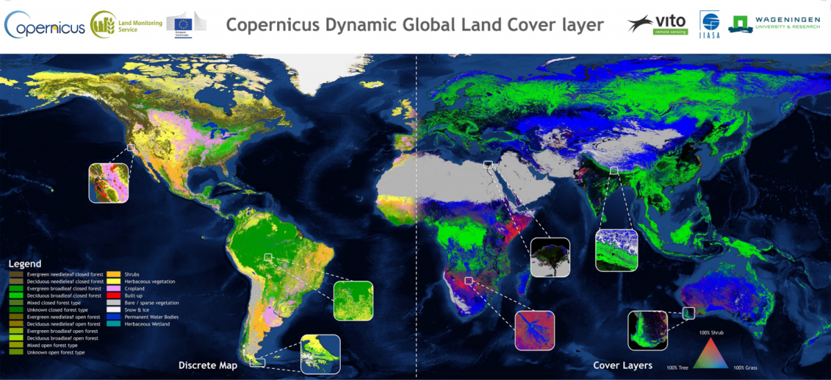
The maps include
- a main discrete classification with 23 classes aligned with UN-FAO's Land Cover Classification System,
- a set of versatile cover fractions: percentage (%) of ground cover for the 10 main classes
- a forest type layer
- quality layers on input data density and on the confidence of the detected land cover change
Files
ALandCover_global_discrete-and-FCC.png
Files
(41.2 GB)
| Name | Size | |
|---|---|---|
|
md5:e50e2888d05319db7ca888c0c5d454ff
|
1.1 MB | Preview Download |
|
md5:f2c9432c37ced7af02b6d9207036c2dc
|
3.2 GB | Preview Download |
|
md5:ea75607eebe5ce1ea2171e6bcac1c8c5
|
585.1 MB | Preview Download |
|
md5:3fd223c03723b8b07a748ef3cc9fc819
|
151.8 MB | Preview Download |
|
md5:70fbae5079a9af854025abe33a4aecde
|
3.0 GB | Preview Download |
|
md5:9fb7b86b8eb9e098b3989ebd1edcbd46
|
3.8 GB | Preview Download |
|
md5:6898fbe3fb46a1110cd65e3a81ed7624
|
1.7 GB | Preview Download |
|
md5:d49f8c21cbf36fc51aff08c4a8306a4f
|
7.7 GB | Preview Download |
|
md5:17aed9604a2df8f0247f0ff0e297c1c4
|
1.0 GB | Preview Download |
|
md5:129da8d091706d52e98e4d253a49a1ba
|
7.3 GB | Preview Download |
|
md5:aa1c8a82bf15df43da388d39496e8702
|
306.7 MB | Preview Download |
|
md5:6f1b2d8efeb5cde02e99bfc183eb4888
|
493.8 MB | Preview Download |
|
md5:c83ad4a378b4b0739d116168bf65f1e4
|
603.5 MB | Preview Download |
|
md5:5da6afc41700b9b4e7e9d130e5a8a6a4
|
5.6 GB | Preview Download |
|
md5:3de6692f104fb0920da471c1b2af47ec
|
111.8 MB | Preview Download |
|
md5:37b7914dd88503a41b88f6445700e425
|
5.7 GB | Preview Download |